Geolocate

Fuday topographic map

Interactive map

Click on the map to display elevation.

About this map

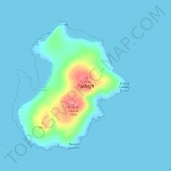
Name: Fuday topographic map, elevation, terrain.

Location: Fuday, Western Isles, Scotland, United Kingdom (57.04231 -7.40288 57.06231 -7.37138)

Average elevation: 9 m

Minimum elevation: -1 m

Maximum elevation: 84 m

Other topographic maps

Click on a map to view its topography, its elevation and its terrain.

Kingussie

United Kingdom > Scotland > Highland

Average elevation: 338 m

Calvine

United Kingdom > Scotland > Perth and Kinross

Average elevation: 273 m

Aberlemno

United Kingdom > Scotland > Angus

Average elevation: 114 m

Strachan

United Kingdom > Scotland > Aberdeenshire

Average elevation: 148 m

Dornie

United Kingdom > Scotland > Highland

Average elevation: 131 m

Newbridge

United Kingdom > Scotland > City of Edinburgh

Average elevation: 54 m

Dunoon

United Kingdom > Scotland > Argyll and Bute

Average elevation: 98 m

Milnathort

United Kingdom > Scotland > Perth and Kinross

Average elevation: 130 m

Caithness

United Kingdom > Scotland

Caithness extends about 30 miles (48 km) north-south and about 30 miles (48 km) east-west, with a roughly triangular-shaped area of about 712 sq mi (1,840 km2). The topography is generally flat, in contrast to the majority of the remainder of the North of Scotland. Until the latter part of the 20th century…

Average elevation: 79 m

Ardbeg

United Kingdom > Scotland > Argyll and Bute

Average elevation: 31 m

Longshaw

United Kingdom > Scotland > Scottish Borders

Average elevation: 378 m

Dundee

United Kingdom > Scotland > Dundee City

Dundee sits on the north bank of the Firth of Tay on the eastern, North Sea Coast of Scotland. The city lies 36.1 miles (58 km) NNE of Edinburgh and 360.6 miles (580 km) NNW of London. The built-up area occupies a roughly rectangular shape 8.3 miles (13 km) long by 2.5 miles (4 km) wide, aligned in an east to…

Average elevation: 83 m

Bonnybridge

United Kingdom > Scotland > Falkirk

Average elevation: 84 m

Peterculter

United Kingdom > Scotland > Aberdeen City

Average elevation: 62 m

Perth and Kinross

United Kingdom > Scotland

Average elevation: 338 m

Cannich

United Kingdom > Scotland > Highland

Average elevation: 204 m

Ling

United Kingdom > Scotland > Argyll and Bute

Average elevation: 29 m

Angus

United Kingdom > Scotland

Angus can be split into three geographic areas. To the north and west, the topography is mountainous. This is the area of the Grampian Mountains, Mounth hills and Five Glens of Angus, which is sparsely populated and where the main industry is hill farming. Glas Maol – the highest point in Angus at 1,068 m…

Average elevation: 254 m

Law

United Kingdom > Scotland > South Lanarkshire

Average elevation: 143 m

Grantown-on-Spey

United Kingdom > Scotland > Highland

Average elevation: 271 m

Drumnadrochit

United Kingdom > Scotland > Highland

Average elevation: 159 m

Cougie

United Kingdom > Scotland > Highland

Average elevation: 397 m

Perth

United Kingdom > Scotland > Perth and Kinross

Average elevation: 131 m

Muirfield

United Kingdom > Scotland > Scottish Borders

Average elevation: 227 m

Garmouth

United Kingdom > Scotland > Moray

Average elevation: 11 m

Alford

United Kingdom > Scotland > Aberdeenshire

Average elevation: 189 m

Larkhall

United Kingdom > Scotland > South Lanarkshire

Average elevation: 114 m

Viewfield

United Kingdom > Scotland > Scottish Borders

Average elevation: 136 m

Airdrie

United Kingdom > Scotland > North Lanarkshire

Airdrie's name first appeared in the Register of the Great Seal of Scotland (Latin: Registrum Magni Sigilii Regum Scotorum) in 1373 as Ardre. By 1546 it had become Ardry and by 1587 it was known as Ardrie. In 1630 it finally appeared in the Register as Airdrie. Given the topography of the area, the most likely…

Average elevation: 136 m

Dyke

United Kingdom > Scotland > Moray

Average elevation: 24 m

Hawick

United Kingdom > Scotland > Scottish Borders

Average elevation: 199 m

North Berwick

United Kingdom > Scotland > East Lothian

Average elevation: 21 m

St Andrews

United Kingdom > Scotland > Fife

Average elevation: 38 m

Pierowall

United Kingdom > Scotland > Orkney Islands

Average elevation: 20 m

Ruthven

United Kingdom > Scotland > Aberdeenshire

Average elevation: 132 m

Stromness

United Kingdom > Scotland > Orkney Islands

Average elevation: 21 m

Findhorn

United Kingdom > Scotland > Moray

Average elevation: 3 m

Culloden

United Kingdom > Scotland > Highland

Average elevation: 51 m

Kirkcaldy

United Kingdom > Scotland > Fife

Towards the end of the 16th century, a detailed assessment on the size of the townscape was carried out. The first estimate of the parish population in 1639 was between 3,000 and 3,200 and around 3,400 by 1691. At the beginning of the 18th century, the population declined. A census by Webster's Topographical…

Average elevation: 50 m

Forres

United Kingdom > Scotland > Moray

Average elevation: 31 m

Bellshill

United Kingdom > Scotland > North Lanarkshire

Average elevation: 73 m

Ben Macdui

United Kingdom > Scotland > Aberdeenshire

Average elevation: 1,031 m

Braemar

United Kingdom > Scotland > Aberdeenshire

Braemar /breɪˈmɑːr/ is a village in Aberdeenshire, Scotland, around 58 miles (93 km) west of Aberdeen in the Highlands. It is the closest significantly-sized settlement to the upper course of the River Dee, sitting at an elevation of 339 metres (1,112 ft).

Average elevation: 445 m

Ailsa Craig

United Kingdom > Scotland

In a small glen above Ailsa Castle, a small freshwater body known as the Garry Loch is located at an altitude of 247 m (810 ft), with a depth of at least 17 feet.

Average elevation: 14 m

Cairnhill

United Kingdom > Scotland > North Lanarkshire > Airdrie

Average elevation: 112 m

Iona

United Kingdom > Scotland > Argyll and Bute > The Village

Average elevation: 9 m

Morar

United Kingdom > Scotland > Highland

Average elevation: 30 m

Dunphail

United Kingdom > Scotland > Moray

Average elevation: 192 m

Bowling

United Kingdom > Scotland > West Dunbartonshire

Average elevation: 105 m

Carron

United Kingdom > Scotland > Falkirk

Average elevation: 16 m

Sandbank

United Kingdom > Scotland > Argyll and Bute

Average elevation: 100 m

Wick

United Kingdom > Scotland > Highland

Average elevation: 20 m

Duns

United Kingdom > Scotland > Berwickshire

Average elevation: 130 m

Portgordon

United Kingdom > Scotland > Moray

Average elevation: 22 m

Burray

United Kingdom > Scotland > Orkney Islands

Average elevation: 7 m

Viewpark

United Kingdom > Scotland > North Lanarkshire

Average elevation: 62 m

Callander

United Kingdom > Scotland > Stirling

Average elevation: 203 m

Leapark

United Kingdom > Scotland > Angus > Royal Burgh of Forfar

Average elevation: 104 m

Cranston

United Kingdom > Scotland > Midlothian > Ford

Average elevation: 154 m

Millhill

United Kingdom > Scotland > North Ayrshire

Average elevation: 163 m

Tiree

United Kingdom > Scotland > Argyll and Bute > Balevullin

Average elevation: 3 m

Cumnock

United Kingdom > Scotland > East Ayrshire

Average elevation: 187 m

Colonsay

United Kingdom > Scotland > Argyll and Bute > Scalasaig

Average elevation: 11 m

Scarp

United Kingdom > Scotland > Western Isles

Average elevation: 56 m

Galashiels

United Kingdom > Scotland > Scottish Borders

Average elevation: 221 m

Loch Ness

United Kingdom > Scotland > Highland > Dores

Average elevation: 340 m

Fintry

United Kingdom > Scotland > Stirling

Average elevation: 230 m

Biggar

United Kingdom > Scotland > South Lanarkshire

Biggar has an oceanic climate (Köppen: Cfb). Camps Reservoir is a nearby weather station situated at an elevation of 295 m (968 ft).

Average elevation: 254 m

Birsay

United Kingdom > Scotland > Orkney Islands

Average elevation: 18 m

Lyness

United Kingdom > Scotland > Orkney Islands

Average elevation: 28 m

Glenrothes

United Kingdom > Scotland > Fife

Average elevation: 106 m

Milltimber

United Kingdom > Scotland > Aberdeen City

Average elevation: 74 m

Mintlaw

United Kingdom > Scotland > Aberdeenshire

Average elevation: 48 m

Eddleston

United Kingdom > Scotland > Scottish Borders

Average elevation: 282 m

Sutherland

United Kingdom > Scotland

Average elevation: 109 m

Errol

United Kingdom > Scotland > Perth and Kinross

Average elevation: 13 m

Salen

United Kingdom > Scotland > Highland > Salen

Average elevation: 83 m

Dunbar

United Kingdom > Scotland > East Lothian

Average elevation: 24 m

Camore

United Kingdom > Scotland > Highland > Evelix

Average elevation: 31 m

Ardrossan

United Kingdom > Scotland > North Ayrshire

Average elevation: 21 m

Freuchie

United Kingdom > Scotland > Fife

Average elevation: 78 m

Busby

United Kingdom > Scotland > East Renfrewshire

Average elevation: 104 m

Harburn

United Kingdom > Scotland > West Lothian

Average elevation: 229 m

Loch Etive

United Kingdom > Scotland > Argyll and Bute > Connel

Average elevation: 318 m

Bonnyrigg

United Kingdom > Scotland > Midlothian > Bonnyrigg

Average elevation: 114 m

Kiltarlity

United Kingdom > Scotland > Highland > Kiltarlity

Average elevation: 66 m

Ballater

United Kingdom > Scotland > Aberdeenshire > Ballater

Ballater (/ˈbælətər/, Scottish Gaelic: Bealadair) is a village in Aberdeenshire, Scotland on the River Dee, immediately east of the Cairngorm Mountains. Situated at an elevation of 213 metres (699 feet), Ballater is a centre for hikers and known for its spring water, once said to cure scrofula. It is home…

Average elevation: 360 m

Kinlochard

United Kingdom > Scotland > Stirling > Kinlochard

Average elevation: 177 m

Contin

United Kingdom > Scotland > Contin

Average elevation: 73 m

East Kilbride

United Kingdom > Scotland > South Lanarkshire

The earliest-known evidence of occupation in the area dates as far back as the late Neolithic and Early Bronze Age, as archaeological investigation has demonstrated that burial cairns in the district began as ceremonial or ritual sites of burial during the Neolithic, with the use of cup-marked, and other…

Average elevation: 175 m

Northbay

United Kingdom > Scotland > Western Isles

Average elevation: 44 m