Geolocate

Portgordon topographic map

Click on the map to display elevation.

About this map

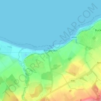
Name: Portgordon topographic map, elevation, terrain.

Location: Portgordon, Moray, Scotland, AB56 5TL, United Kingdom (57.64349 -3.03604 57.68349 -2.99604)

Average elevation: 22 m

Minimum elevation: -2 m

Maximum elevation: 89 m

Gear up for your next adventure:

🥾Trail Running Boots - Durable shoes designed for trail running
💧Hydration Pack - Hands-free hydration system for long hikes
🥾Trekking Boots - Durable boots for long-distance trekking
Bushcraft Tarp - Versatile emergency shelter or gear protection
Lightweight Backpacking Tent - Compact tent for efficient hiking trips

As an Amazon Associate, this site earns from qualifying purchases at no extra cost to you.