Geolocate

Sandbank topographic map

Click on the map to display elevation.

About this map

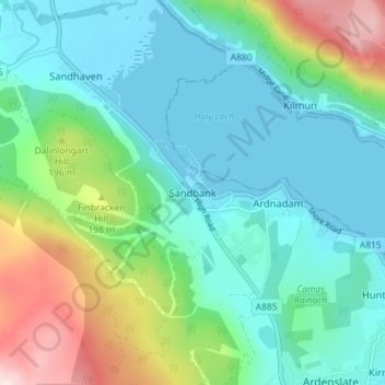
Name: Sandbank topographic map, elevation, terrain.

Location: Sandbank, Argyll and Bute, Scotland, PA23 8PJ, United Kingdom (55.96092 -4.96785 56.00092 -4.92785)

Average elevation: 100 m

Minimum elevation: -1 m

Maximum elevation: 404 m

Other topographic maps

Click on a map to view its topography, its elevation and its terrain.

Tobermory

United Kingdom > Scotland > Argyll and Bute

Average elevation: 58 m

Iona

United Kingdom > Scotland > Argyll and Bute > The Village

Average elevation: 9 m

Tiree

United Kingdom > Scotland > Argyll and Bute > Balevullin

Average elevation: 3 m

Loch Etive

United Kingdom > Scotland > Argyll and Bute > Connel

Average elevation: 318 m

Gear up for your next adventure:

Bushcraft Tarp - Versatile emergency shelter or gear protection
🪑Insulated Seat Pad - Protect your seat from cold rocks and wet logs
🔦LED Headtorch - Bright and durable light for night activities
💡LED Headlamp - Hands-free illumination for night hiking and camping
💧Hydration Bladder - Hands-free hydration solution for long treks

As an Amazon Associate, this site earns from qualifying purchases at no extra cost to you.