Geolocate

Busby topographic map

Click on the map to display elevation.

About this map

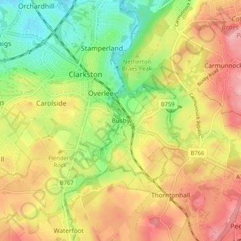
Name: Busby topographic map, elevation, terrain.

Location: Busby, East Renfrewshire, Scotland, G76 8JZ, United Kingdom (55.76157 -4.28581 55.80157 -4.24581)

Average elevation: 104 m

Minimum elevation: 42 m

Maximum elevation: 163 m

Gear up for your next adventure:

🚲MTB Frame Bag - Carry tools and maps directly on your bicycle frame
🧤Thermal Hiking Gloves - Grip-enhanced gloves for cold-weather altitude trekking
🎒Backpack Rain Cover - External shield to keep your entire pack dry
🥾Approach Shoes - Shoes designed for climbing approaches and rugged trails
🔥Emergency Fire Starter - Reliable ignition source for all weather conditions

As an Amazon Associate, this site earns from qualifying purchases at no extra cost to you.