Geolocate

Perth topographic map

Interactive map

Click on the map to display elevation.

About this map

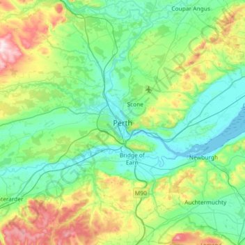
Name: Perth topographic map, elevation, terrain.

Location: Perth, Perth and Kinross, Scotland, PH1 5SU, United Kingdom (56.23582 -3.58868 56.55582 -3.26868)

Average elevation: 131 m

Minimum elevation: -1 m

Maximum elevation: 583 m

Other topographic maps

Click on a map to view its topography, its elevation and its terrain.

Errol

United Kingdom > Scotland > Perth and Kinross

Average elevation: 13 m

Stanley

United Kingdom > Scotland > Perth and Kinross > Stanley

Average elevation: 57 m

Scone

United Kingdom > Scotland > Perth and Kinross

Average elevation: 81 m

Pitlochry

United Kingdom > Scotland > Perth and Kinross

Average elevation: 276 m