Geolocate

Garmouth topographic map

Click on the map to display elevation.

About this map

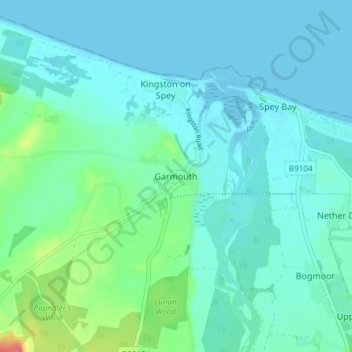
Name: Garmouth topographic map, elevation, terrain.

Location: Garmouth, Moray, Scotland, IV32 7PD, United Kingdom (57.64475 -3.13052 57.68475 -3.09052)

Average elevation: 11 m

Minimum elevation: 0 m

Maximum elevation: 63 m

Gear up for your next adventure:

🩹Compact First Aid Kit - Pre-packed essentials for common trail injuries
Camping Groundsheet - Protect your tent from moisture and dirt
💡Compact LED Flashlight - Powerful and portable flashlight for outdoor use
🦯Trekking Poles - Reduced impact on joints for steep topographic climbs
🦶Anti-Blister Balm - Prevents friction and hotspots during long ascents

As an Amazon Associate, this site earns from qualifying purchases at no extra cost to you.