Geolocate

Loch Ness topographic map

Click on the map to display elevation.

About this map

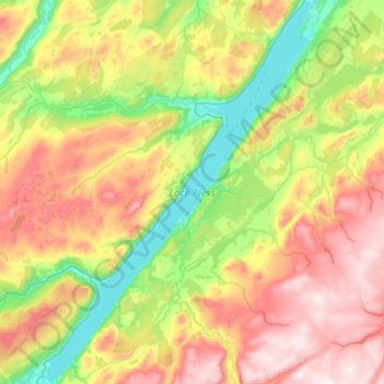
Name: Loch Ness topographic map, elevation, terrain.

Location: Loch Ness, Dores, Highland, Scotland, PH32 4BN, United Kingdom (57.13838 -4.68013 57.40972 -4.32751)

Average elevation: 340 m

Minimum elevation: 8 m

Maximum elevation: 829 m

Gear up for your next adventure:

🧥Thermal Fleece Jacket - Versatile insulation for changing mountain temperatures
🥾Trail Hiking Shoes - Durable shoes designed for rugged trails
🥾Trail Running Boots - Durable shoes designed for trail running
🥾Hiking Leggings - Comfortable leggings for outdoor activities
🥾Trekking Boots - Durable boots for long-distance trekking

As an Amazon Associate, this site earns from qualifying purchases at no extra cost to you.