Geolocate

Cranston topographic map

Click on the map to display elevation.

About this map

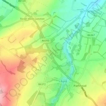
Name: Cranston topographic map, elevation, terrain.

Location: Cranston, Ford, Midlothian, Scotland, EH37 5UB, United Kingdom (55.85955 -3.00571 55.89955 -2.96571)

Average elevation: 154 m

Minimum elevation: 85 m

Maximum elevation: 261 m

Gear up for your next adventure:

Bushcraft Tarp - Versatile emergency shelter or gear protection
🧥Waterproof Hiking Jacket - Protect yourself from rain and wind while hiking
🚲Heavy Duty Bike Lock - Secure your bike at the trailhead or during stops
🛶Canoe Life Vest - Safety vest for water sports
🔪Outdoor Multitool - Versatile tool for repairs and food prep in the wild

As an Amazon Associate, this site earns from qualifying purchases at no extra cost to you.