Geolocate

Dunoon topographic map

Click on the map to display elevation.

About this map

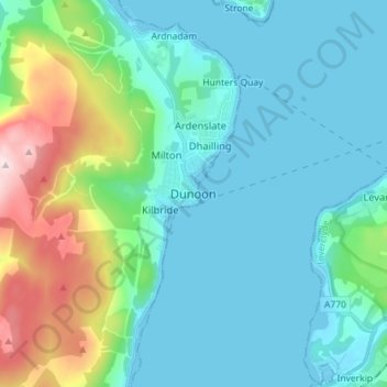
Name: Dunoon topographic map, elevation, terrain.

Location: Dunoon, Argyll and Bute, Scotland, PA23 7HG, United Kingdom (55.90811 -4.96449 55.98811 -4.88449)

Average elevation: 98 m

Minimum elevation: 0 m

Maximum elevation: 500 m

Other topographic maps

Click on a map to view its topography, its elevation and its terrain.

Tobermory

United Kingdom > Scotland > Argyll and Bute

Average elevation: 58 m

Iona

United Kingdom > Scotland > Argyll and Bute > The Village

Average elevation: 9 m

Tiree

United Kingdom > Scotland > Argyll and Bute > Balevullin

Average elevation: 3 m

Loch Etive

United Kingdom > Scotland > Argyll and Bute > Connel

Average elevation: 318 m

Gear up for your next adventure:

📷Outdoor Action Camera - Capture high-elevation views and rugged adventures
🔋Emergency Crank Radio - Weather alerts and power without needing batteries
🕶️Polarized Sunglasses - Protect your eyes with durable polarized lenses
🧢Hiking Sun Hat - Wide-brimmed protection for exposed mountain ridges
🥾Hiking Leggings - Comfortable leggings for outdoor activities

As an Amazon Associate, this site earns from qualifying purchases at no extra cost to you.