Geolocate

Harburn topographic map

Click on the map to display elevation.

About this map

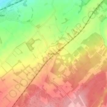
Name: Harburn topographic map, elevation, terrain.

Location: Harburn, West Lothian, Scotland, EH55 8RP, United Kingdom (55.81666 -3.55449 55.85666 -3.51449)

Average elevation: 229 m

Minimum elevation: 151 m

Maximum elevation: 292 m

Gear up for your next adventure:

🥾Lightweight Hiking Boots - Boots for comfort and mobility on long hikes
🔦LED Flashlight - Powerful and long-lasting flashlight for camping and emergencies
🧰Multitool Knife - Compact and versatile tool for outdoor use
🧥Ultralight Puffy Jacket - Maximum warmth that packs down to the size of an orange
🧦Merino Wool Socks - Moisture-wicking comfort for long-distance hiking

As an Amazon Associate, this site earns from qualifying purchases at no extra cost to you.