Geolocate

Wick topographic map

Click on the map to display elevation.

About this map

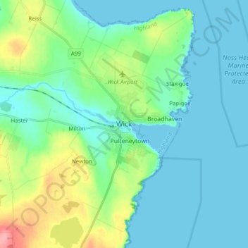
Name: Wick topographic map, elevation, terrain.

Location: Wick, Highland, Scotland, KW1 4NB, United Kingdom (58.40255 -3.13158 58.48255 -3.05158)

Average elevation: 20 m

Minimum elevation: -1 m

Maximum elevation: 90 m

Other topographic maps

Click on a map to view its topography, its elevation and its terrain.

Loch Ness

United Kingdom > Scotland > Highland > Dores

Average elevation: 340 m

Gear up for your next adventure:

🔦LED Flashlight - Powerful and long-lasting flashlight for camping and emergencies
🧤Rechargeable Heated Gloves - Extreme warmth for Canadian winter expeditions
🔨Vehicle Emergency Tool - Safety tool for remote road trips to trailheads
🔭Compact Binoculars - Lightweight optics for scouting trails and wildlife
🧊Portable Cooler - Keep food and drinks cold during outdoor adventures

As an Amazon Associate, this site earns from qualifying purchases at no extra cost to you.