
Strachan topographic map
Click on the map to display elevation.
About this map
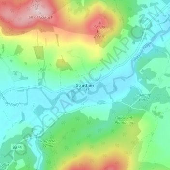
Name: Strachan topographic map, elevation, terrain.
Location: Strachan, Aberdeenshire, Scotland, AB31 6NN, United Kingdom (57.00064 -2.55746 57.04064 -2.51746)
Average elevation: 148 m
Minimum elevation: 70 m
Maximum elevation: 333 m
Other topographic maps
Click on a map to view its topography, its elevation and its terrain.
Chapelton of Elsick
United Kingdom > Scotland > Aberdeenshire
House styles in Chapelton vary from small apartments to five bedroom family homes. The architecture of the houses' exteriors have slate roof tiles and lime harl. Architectural details and materials in the first phase include slate roofs, timber windows (sash and case to public elevations), Dormer|dormer…
Average elevation: 93 m