Geolocate

Forres topographic map

Interactive map

Click on the map to display elevation.

About this map

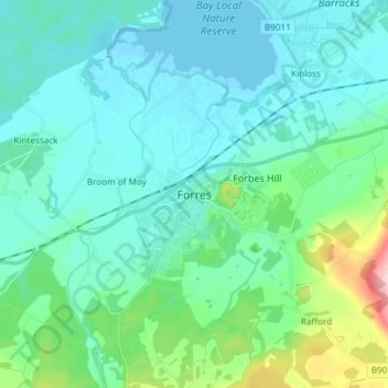
Name: Forres topographic map, elevation, terrain.

Location: Forres, Moray, Scotland, IV36 1NX, United Kingdom (57.56986 -3.65322 57.64986 -3.57322)

Average elevation: 31 m

Minimum elevation: -1 m

Maximum elevation: 179 m

Other topographic maps

Click on a map to view its topography, its elevation and its terrain.

Dyke

United Kingdom > Scotland > Moray

Dyke, Moray, Scotland, IV36 2TJ, United Kingdom

Average elevation: 24 m

Findhorn

United Kingdom > Scotland > Moray

Findhorn, Moray, Scotland, IV36 3YG, United Kingdom

Average elevation: 3 m

Dunphail

United Kingdom > Scotland > Moray

Dunphail, Moray, Scotland, IV36 2QQ, United Kingdom

Average elevation: 192 m

Portgordon

United Kingdom > Scotland > Moray

Portgordon, Moray, Scotland, AB56 5TL, United Kingdom

Average elevation: 22 m

Glenlivet

United Kingdom > Scotland > Moray > Glenlivet

Glenlivet, Moray, Scotland, AB37 9BT, United Kingdom

Average elevation: 280 m