Geolocate

Culloden topographic map

Click on the map to display elevation.

About this map

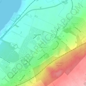
Name: Culloden topographic map, elevation, terrain.

Location: Culloden, Inverness, Highland, Scotland, United Kingdom (57.48002 -4.16990 57.50094 -4.12036)

Average elevation: 51 m

Minimum elevation: 0 m

Maximum elevation: 151 m

Other topographic maps

Click on a map to view its topography, its elevation and its terrain.

Scaniport

United Kingdom > Scotland > Highland > Inverness

Average elevation: 85 m

Loch Ashie

United Kingdom > Scotland > Highland > Inverness

Average elevation: 228 m

Beauly Firth

United Kingdom > Scotland > Highland > Inverness

Average elevation: 4 m

Bunchrew

United Kingdom > Scotland > Highland > Inverness

Average elevation: 66 m

Gear up for your next adventure:

🧥Thermal Layer - Insulating layer for cold outdoor conditions
🔭Compact Binoculars - Lightweight optics for scouting trails and wildlife
🔦UV Flashlight - Detect minerals or specific insects in the dark
🧴Bear Spray Holster - Quick-access carry for essential Canadian wilderness safety
👖Convertible Hiking Pants - Zip-off legs to adapt to changing weather conditions

As an Amazon Associate, this site earns from qualifying purchases at no extra cost to you.