Geolocate

Birsay topographic map

Click on the map to display elevation.

About this map

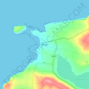
Name: Birsay topographic map, elevation, terrain.

Location: Birsay, Orkney Islands, Scotland, KW17 2LL, United Kingdom (59.10954 -3.33337 59.14954 -3.29337)

Average elevation: 18 m

Minimum elevation: 0 m

Maximum elevation: 101 m

Other topographic maps

Click on a map to view its topography, its elevation and its terrain.

Burray

United Kingdom > Scotland > Orkney Islands

Average elevation: 7 m

Gear up for your next adventure:

🧶550 Survival Paracord - Versatile utility cord for emergency repairs and rigging
🧊Insulated Water Bottle - Keeps drinks cold in summer and prevents freezing in winter
🥾Trail Hiking Socks - Comfortable socks to prevent blisters and fatigue
🕶️Polarized Sunglasses - Protect your eyes with durable polarized lenses
🦶Anti-Blister Balm - Prevents friction and hotspots during long ascents

As an Amazon Associate, this site earns from qualifying purchases at no extra cost to you.