
Make a donation
Gear up for your next adventure:
As an Amazon Associate, this site earns from qualifying purchases at no extra cost to you.
Alford topographic map
Click on the map to display elevation.
Make a donation
Gear up for your next adventure:
As an Amazon Associate, this site earns from qualifying purchases at no extra cost to you.
About this map
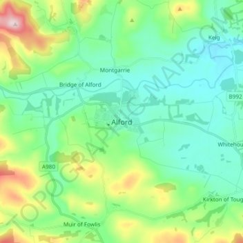
Name: Alford topographic map, elevation, terrain.
Location: Alford, Aberdeenshire, Scotland, AB33 8PX, United Kingdom (57.19185 -2.74163 57.27185 -2.66163)
Average elevation: 189 m
Minimum elevation: 112 m
Maximum elevation: 416 m
Make a donation
Gear up for your next adventure:
As an Amazon Associate, this site earns from qualifying purchases at no extra cost to you.
Other topographic maps
Click on a map to view its topography, its elevation and its terrain.
Chapelton of Elsick
United Kingdom > Scotland > Aberdeenshire
House styles in Chapelton vary from small apartments to five bedroom family homes. The architecture of the houses' exteriors have slate roof tiles and lime harl. Architectural details and materials in the first phase include slate roofs, timber windows (sash and case to public elevations), Dormer|dormer…
Average elevation: 93 m