Geolocate

Millhill topographic map

Click on the map to display elevation.

About this map

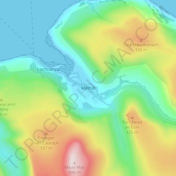
Name: Millhill topographic map, elevation, terrain.

Location: Millhill, North Ayrshire, Scotland, KA27 8HQ, United Kingdom (55.68030 -5.29907 55.72030 -5.25907)

Average elevation: 163 m

Minimum elevation: 0 m

Maximum elevation: 491 m

Gear up for your next adventure:

🎒Fully Waterproof Backpack - Total protection for photography gear and electronics
🥾Trekking Poles - Adjustable trekking poles to reduce knee stress and improve stability
🔦LED Flashlight - Powerful and long-lasting flashlight for camping and emergencies
Camping Tent - Weather-resistant tents suitable for 2 to 6 people
📷Outdoor Action Camera - Capture high-elevation views and rugged adventures

As an Amazon Associate, this site earns from qualifying purchases at no extra cost to you.