Geolocate

Galashiels topographic map

Click on the map to display elevation.

About this map

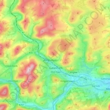
Name: Galashiels topographic map, elevation, terrain.

Location: Galashiels, Scottish Borders, Scotland, United Kingdom (55.57887 -2.86204 55.67654 -2.75064)

Average elevation: 221 m

Minimum elevation: 83 m

Maximum elevation: 423 m

Other topographic maps

Click on a map to view its topography, its elevation and its terrain.

Hawick

United Kingdom > Scotland > Scottish Borders

Average elevation: 199 m

Longshaw

United Kingdom > Scotland > Scottish Borders

Average elevation: 378 m

Viewfield

United Kingdom > Scotland > Scottish Borders

Average elevation: 136 m

Muirfield

United Kingdom > Scotland > Scottish Borders

Average elevation: 227 m

Cavers

United Kingdom > Scotland > Scottish Borders > Cavers

Average elevation: 157 m

Gear up for your next adventure:

❄️Traction Ice Cleats - Slip-on spikes for icy trails and winter hiking
🧴Bear Spray Holster - Quick-access carry for essential Canadian wilderness safety
🥾Trekking Poles - Adjustable trekking poles to reduce knee stress and improve stability
🧥Thermal Fleece Jacket - Versatile insulation for changing mountain temperatures
🚑Survival Whistle - Signal for help across long distances in mountains

As an Amazon Associate, this site earns from qualifying purchases at no extra cost to you.