Geolocate

Drumnadrochit topographic map

Click on the map to display elevation.

About this map

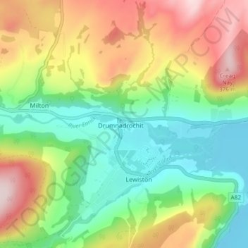
Name: Drumnadrochit topographic map, elevation, terrain.

Location: Drumnadrochit, Highland, Scotland, IV63 6TX, United Kingdom (57.31623 -4.49980 57.35623 -4.45980)

Average elevation: 159 m

Minimum elevation: 12 m

Maximum elevation: 383 m

Other topographic maps

Click on a map to view its topography, its elevation and its terrain.

Loch Ness

United Kingdom > Scotland > Highland > Dores

Average elevation: 340 m

Gear up for your next adventure:

🔦UV Flashlight - Detect minerals or specific insects in the dark
🧭GPS Tracker - Track your location in remote areas safely
🔦LED Headtorch - Bright and durable light for night activities
💧Collapsible Water Bottle - Space-saving water bottle for outdoor activities
🥾Trail Hiking Socks - Comfortable socks to prevent blisters and fatigue

As an Amazon Associate, this site earns from qualifying purchases at no extra cost to you.