
Ailsa Craig topographic map
Click on the map to display elevation.
Ailsa Craig
In a small glen above Ailsa Castle, a small freshwater body known as the Garry Loch is located at an altitude of 247 m (810 ft), with a depth of at least 17 feet.
About this map
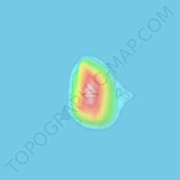
Name: Ailsa Craig topographic map, elevation, terrain.
Location: Ailsa Craig, Scotland, United Kingdom (55.25269 -5.11822 55.25279 -5.11812)
Average elevation: 14 m
Minimum elevation: 0 m
Maximum elevation: 333 m
Other topographic maps
Click on a map to view its topography, its elevation and its terrain.
Caithness
Caithness extends about 30 miles (48 km) north-south and about 30 miles (48 km) east-west, with a roughly triangular-shaped area of about 712 sq mi (1,840 km2). The topography is generally flat, in contrast to the majority of the remainder of the North of Scotland. Until the latter part of the 20th century…
Average elevation: 79 m
Glen Finglas Dam And Hydro-Electric Power Station
United Kingdom > Scotland > Stirling
Average elevation: 235 m
Lerwick
United Kingdom > Scotland > Lerwick
Lerwick has a subpolar oceanic climate (Cfc) with cool to cold temperatures all year long. The lack of trees reflects the latter type. This is particularly pronounced by virtue of Lerwick being on the coast of an island, so even extreme temperature records are subdued; the record high stands at just 23.4 °C…
Average elevation: 34 m
Chapelton of Elsick
United Kingdom > Scotland > Aberdeenshire
House styles in Chapelton vary from small apartments to five bedroom family homes. The architecture of the houses' exteriors have slate roof tiles and lime harl. Architectural details and materials in the first phase include slate roofs, timber windows (sash and case to public elevations), Dormer|dormer…
Average elevation: 93 m