Geolocate

Ling topographic map

Click on the map to display elevation.

About this map

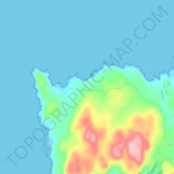
Name: Ling topographic map, elevation, terrain.

Location: Ling, Argyll and Bute, Scotland, PA75 6QY, United Kingdom (56.58181 -6.32139 56.62181 -6.28139)

Average elevation: 29 m

Minimum elevation: 0 m

Maximum elevation: 163 m

Other topographic maps

Click on a map to view its topography, its elevation and its terrain.

Iona

United Kingdom > Scotland > Argyll and Bute > The Village

Average elevation: 9 m

Tobermory

United Kingdom > Scotland > Argyll and Bute

Average elevation: 58 m

Tiree

United Kingdom > Scotland > Argyll and Bute > Balevullin

Average elevation: 3 m

Loch Etive

United Kingdom > Scotland > Argyll and Bute > Connel

Average elevation: 318 m

Gear up for your next adventure:

🥾Waterproof Hiking Shoes - Durable shoes for wet and rugged trails
💧Reusable Water Bottle - Durable water bottles for hydration on trails
🦶Hiking Shoe Insoles - Added support for high arches and long days on feet
🧢Beanie Hat - Keep your head warm in cold weather
🧊Insulated Water Bottle - Keeps drinks cold in summer and prevents freezing in winter

As an Amazon Associate, this site earns from qualifying purchases at no extra cost to you.