Geolocate

Stromness topographic map

Interactive map

Click on the map to display elevation.

About this map

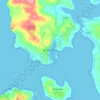
Name: Stromness topographic map, elevation, terrain.

Location: Stromness, Orkney Islands, Scotland, KW16 3BU, United Kingdom (58.92144 -3.33938 59.00144 -3.25938)

Average elevation: 21 m

Minimum elevation: -1 m

Maximum elevation: 157 m

Other topographic maps

Click on a map to view its topography, its elevation and its terrain.

Pierowall

United Kingdom > Scotland > Orkney Islands

Average elevation: 20 m

Kirkwall

United Kingdom > Scotland > Orkney Islands

Average elevation: 27 m

Burray

United Kingdom > Scotland > Orkney Islands

Average elevation: 7 m

Birsay

United Kingdom > Scotland > Orkney Islands

Average elevation: 18 m

Lyness

United Kingdom > Scotland > Orkney Islands

Average elevation: 28 m

Dounby

United Kingdom > Scotland > Orkney Islands > Dounby

Average elevation: 23 m

Orkney Islands

United Kingdom > Scotland > Orkney Islands

The southern group of islands surrounds Scapa Flow. Hoy, to the west, is the second largest of the Orkney Isles and Ward Hill at its northern end is the highest elevation in the archipelago. The Old Man of Hoy is a well-known seastack. Graemsay and Flotta are both linked by ferry to the Mainland and Hoy, and…

Average elevation: 9 m