Sitapur topographic map
Interactive map
Click on the map to display elevation.
About this map
![Sitapur topographic map, elevation, terrain](/pub/maps/relation/rz4/w3v8nh/thumbnail.jpg)
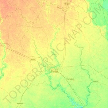
Name: Sitapur topographic map, elevation, terrain.
Location: Sitapur, Sitapur District, Uttar Pradesh, India (27.41543 80.53026 27.83920 80.85354)
Average elevation: 140 m
Minimum elevation: 123 m
Maximum elevation: 151 m
Other topographic maps
Click on a map to view its topography, its elevation and its terrain.
![Nagina topographic map, elevation, terrain](/pub/maps/node/1jm2/htnv91mt/icon.jpg)
Nagina
India > Uttar Pradesh > Nagina
Nagina, Bijnor District, Uttar Pradesh, 246762, India
Average elevation: 246 m
![Deval topographic map, elevation, terrain](/pub/maps/node/9qf3/gxt1dnz4/icon.jpg)
Deval
India > Uttar Pradesh > Jansath
Deval, Jansath, Muzaffarnagar District, Uttar Pradesh, India
Average elevation: 227 m
![Lucknow topographic map, elevation, terrain](/pub/maps/node/g25k/6nk7hmt/icon.jpg)
Lucknow
India > Uttar Pradesh > Lucknow
Lucknow, Lucknow District, Uttar Pradesh, 226027, India
Average elevation: 120 m
![elevated park topographic map, elevation, terrain](/pub/maps/way/ld18/slk8m418/icon.jpg)
elevated park
India > Uttar Pradesh > Kanpur
elevated park, Kanpur, Kanpur Nagar District, Uttar Pradesh, India
Average elevation: 130 m
![Kheri topographic map, elevation, terrain](/pub/maps/node/lr18/dl73p5kl/icon.jpg)
Kheri
India > Uttar Pradesh > Lakhimpur
Kheri, Lakhimpur, Lakhimpur Kheri District, Uttar Pradesh, 262700, India
Average elevation: 144 m
![Fatehpur topographic map, elevation, terrain](/pub/maps/relation/12rr/1wfr57/icon.jpg)
Fatehpur
Fatehpur, Barabanki District, Uttar Pradesh, India
Average elevation: 123 m
![Uska Bazar topographic map, elevation, terrain](/pub/maps/node/xz4/kgm8nc3l/icon.jpg)
Uska Bazar
India > Uttar Pradesh > Naugarh
Uska Bazar, Naugarh, Siddharthnagar District, Uttar Pradesh, India
Average elevation: 85 m
![Naugarh topographic map, elevation, terrain](/pub/maps/relation/gxkl/j6drb3/icon.jpg)
Naugarh
Naugarh, Siddharthnagar District, Uttar Pradesh, India
Average elevation: 88 m
![Dadri Converter Electrode topographic map, elevation, terrain](/pub/maps/way/7kkl/qwdbt57/icon.jpg)
Dadri Converter Electrode
India > Uttar Pradesh > Gautam Buddha Nagar
Dadri Converter Electrode, Gautam Buddha Nagar, Gautam Buddha Nagar District, Uttar Pradesh, India
Average elevation: 197 m
![Sitapur topographic map, elevation, terrain](/pub/maps/node/w18/4j8653q/icon.jpg)
Sitapur
India > Uttar Pradesh > Sitapur
Sitapur, Sitapur District, Uttar Pradesh, 261001, India
Average elevation: 138 m
![Patti topographic map, elevation, terrain](/pub/maps/node/hcz/6n72hmt/icon.jpg)
Patti
India > Uttar Pradesh > Pratapgarh District
Patti, Pratapgarh District, Uttar Pradesh, 230135, India
Average elevation: 93 m
![Bewar topographic map, elevation, terrain](/pub/maps/node/9cs8/v2k1nzm2/icon.jpg)
Bewar
India > Uttar Pradesh > Bhogaon
Bewar, Bhogaon, Mainpuri District, Uttar Pradesh, 206300, India
Average elevation: 151 m
![Sahaspur topographic map, elevation, terrain](/pub/maps/node/9ls8/kpxpj1h/icon.jpg)
Sahaspur
India > Uttar Pradesh > Dhampur
Sahaspur, Dhampur, Bijnor District, Uttar Pradesh, 246745, India
Average elevation: 217 m
![Burhanpur topographic map, elevation, terrain](/pub/maps/relation/bvt6/c9cmtf/icon.jpg)
Burhanpur
Burhanpur, Azamgarh District, Uttar Pradesh, India
Average elevation: 82 m
![Ghatampur topographic map, elevation, terrain](/pub/maps/node/dqb3/b3jsxzs/icon.jpg)
Ghatampur
India > Uttar Pradesh > Ghatampur
Ghatampur, Kanpur Nagar District, Uttar Pradesh, 209206, India
Average elevation: 124 m
![Badlapur topographic map, elevation, terrain](/pub/maps/relation/whtf/6h7v51/icon.jpg)
Badlapur
Badlapur, Jaunpur District, Uttar Pradesh, India
Average elevation: 87 m
![Saisaiya topographic map, elevation, terrain](/pub/maps/node/x6kl/3jkg8q14/icon.jpg)
Saisaiya
India > Uttar Pradesh > Dhaurahara
Saisaiya, Dhaurahara, Lakhimpur Kheri District, Uttar Pradesh, 261502, India
Average elevation: 130 m
![Jaithra topographic map, elevation, terrain](/pub/maps/node/3p18/m8t49w1h/icon.jpg)
Jaithra
India > Uttar Pradesh > Aliganj
Jaithra, Aliganj, Etah District, Uttar Pradesh, 207249, India
Average elevation: 162 m
![Sabota Mustafabad topographic map, elevation, terrain](/pub/maps/node/psrr/88czmqrr/icon.jpg)
Sabota Mustafabad
India > Uttar Pradesh > Jewar
Sabota Mustafabad, Jewar, Gautam Buddha Nagar District, Uttar Pradesh, 203135, India
Average elevation: 197 m
![Nanpara topographic map, elevation, terrain](/pub/maps/relation/svb3/gst3z4/icon.jpg)
Nanpara
Nanpara, Bahraich District, Uttar Pradesh, India
Average elevation: 163 m
![Mohanlalganj topographic map, elevation, terrain](/pub/maps/relation/zs8/8rx5tj/icon.jpg)
Mohanlalganj
Mohanlalganj, Lucknow District, Uttar Pradesh, India
Average elevation: 117 m
![Jajmau topographic map, elevation, terrain](/pub/maps/node/k3f3/pm2cjnh/icon.jpg)
Jajmau
India > Uttar Pradesh > Kanpur
Jajmau, Kanpur, Kanpur Nagar District, Uttar Pradesh, 208015, India
Average elevation: 124 m
![Vikram Nagar topographic map, elevation, terrain](/pub/maps/node/gr57/nvtn22m2/icon.jpg)
Vikram Nagar
India > Uttar Pradesh > Lucknow
Vikram Nagar, Lucknow, Lucknow District, Uttar Pradesh, 226008, India
Average elevation: 124 m
![Naini topographic map, elevation, terrain](/pub/maps/node/zm57/lwrd7k18/icon.jpg)
Naini
India > Uttar Pradesh > Karchhana
Naini, Karchhana, Prayagraj District, Uttar Pradesh, 211108, India
Average elevation: 90 m
![Maudaha topographic map, elevation, terrain](/pub/maps/node/9v9m/vpj2dhm2/icon.jpg)
Maudaha
India > Uttar Pradesh > Hamirpur District
Maudaha, Hamirpur District, Uttar Pradesh, India
Average elevation: 121 m
![Babaganj topographic map, elevation, terrain](/pub/maps/node/m3q/dt1lfhzs/icon.jpg)
Babaganj
India > Uttar Pradesh > Fatehpur
Babaganj, Fatehpur, Barabanki District, Uttar Pradesh, India
Average elevation: 127 m
![Mahrauni topographic map, elevation, terrain](/pub/maps/node/mq1h/zmktq2tj/icon.jpg)
Mahrauni
India > Uttar Pradesh > Mahroni Tehsil
Mahrauni, Mahroni Tehsil, Lalitpur District, Uttar Pradesh, 284405, India
Average elevation: 367 m
![disaunigang topographic map, elevation, terrain](/pub/maps/node/fqkl/sr1385mt/icon.jpg)
disaunigang
India > Uttar Pradesh > Bisauli
disaunigang, Bisauli, Badaun District, Uttar Pradesh, 243725, India
Average elevation: 179 m
![Barhan topographic map, elevation, terrain](/pub/maps/node/pb3/sgwgl4mt/icon.jpg)
Barhan
Barhan, Etmadpur, Agra District, Uttar Pradesh, 283201, India
Average elevation: 171 m
![Nanpara topographic map, elevation, terrain](/pub/maps/node/m3gp/h5mk7tj/icon.jpg)
Nanpara
India > Uttar Pradesh > Nanpara
Nanpara, Bahraich District, Uttar Pradesh, 271865, India
Average elevation: 135 m
![Ganj Dundwara topographic map, elevation, terrain](/pub/maps/node/hstp/hhkb9j3q/icon.jpg)
Ganj Dundwara
India > Uttar Pradesh > Patiyali
Ganj Dundwara, Patiyali, Kasganj District, Uttar Pradesh, 207242, India
Average elevation: 167 m
![Nawab Ganj topographic map, elevation, terrain](/pub/maps/node/wdt6/49hhfpm2/icon.jpg)
Nawab Ganj
India > Uttar Pradesh > Hasanganj
Nawab Ganj, Hasanganj, Unnao District, Uttar Pradesh, India
Average elevation: 124 m
![Derapur topographic map, elevation, terrain](/pub/maps/node/671h/5sqk63l/icon.jpg)
Derapur
India > Uttar Pradesh > Derapur
Derapur, Kanpur Dehat District, Uttar Pradesh, 209301, India
Average elevation: 129 m
![Rampur topographic map, elevation, terrain](/pub/maps/relation/8551/blkx9m/icon.jpg)
Rampur
Rampur, Rampur District, Uttar Pradesh, 244901, India
Average elevation: 190 m
![Afzalgarh topographic map, elevation, terrain](/pub/maps/node/kt9m/g8j3bf3/icon.jpg)
Afzalgarh
India > Uttar Pradesh > Dhampur
Afzalgarh, Dhampur, Bijnor District, Uttar Pradesh, 246722, India
Average elevation: 233 m
![Palia Kalan topographic map, elevation, terrain](/pub/maps/node/kg4s/zdrslt6/icon.jpg)
Palia Kalan
India > Uttar Pradesh > Palia
Palia Kalan, Palia, Lakhimpur Kheri District, Uttar Pradesh, 262902, India
Average elevation: 157 m
![Gajraulla Jai Singh topographic map, elevation, terrain](/pub/maps/node/r6tj/jnjmwg4s/icon.jpg)
Gajraulla Jai Singh
India > Uttar Pradesh > Thakurdwara
Gajraulla Jai Singh, Thakurdwara, Moradabad District, Uttar Pradesh, India
Average elevation: 211 m
![Dohrighat topographic map, elevation, terrain](/pub/maps/node/ntj/755hk6t6/icon.jpg)
Dohrighat
India > Uttar Pradesh > Ghosi
Dohrighat, Ghosi, Mau District, Uttar Pradesh, 275303, India
Average elevation: 72 m
![Tulsipur topographic map, elevation, terrain](/pub/maps/relation/dj18/x3pvtp/icon.jpg)
Tulsipur
Tulsipur, Balrampur District, Uttar Pradesh, India
Average elevation: 157 m
![Kheria topographic map, elevation, terrain](/pub/maps/node/22cz/9jvwd8tf/icon.jpg)
Kheria
India > Uttar Pradesh > Agra
Kheria, Agra, Agra District, Uttar Pradesh, 282001, India
Average elevation: 167 m
![Tiwariganj topographic map, elevation, terrain](/pub/maps/node/43rr/h466m3rr/icon.jpg)
Tiwariganj
India > Uttar Pradesh > Lucknow
Tiwariganj, Lucknow, Lucknow District, Uttar Pradesh, 226028, India
Average elevation: 117 m
![Kushinagar District topographic map, elevation, terrain](/pub/maps/relation/sw51/hzfdmt/icon.jpg)
Kushinagar District
Kushinagar District, Uttar Pradesh, India
Average elevation: 87 m