Geolocate

Moradabad topographic map

Click on the map to display elevation.

About this map

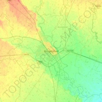
Name: Moradabad topographic map, elevation, terrain.

Location: Moradabad, Uttar Pradesh, 244001, India (28.67350 78.61329 28.99350 78.93329)

Average elevation: 198 m

Minimum elevation: 181 m

Maximum elevation: 219 m

Gear up for your next adventure:

🥾Approach Boots - Comfortable boots for hiking and climbing approaches
🥾Mountain Hiking Boots - High-traction boots for rocky terrain
🦌Outdoor Trail Camera - Monitor wildlife activity near your favorite spots
🥾Durable Hiking Shoes - Long-lasting shoes for frequent hiking
🗺️Topographic Maps - Detailed maps to explore trails, mountains, and wilderness areas

As an Amazon Associate, this site earns from qualifying purchases at no extra cost to you.