Geolocate

Meerut topographic map

Click on the map to display elevation.

About this map

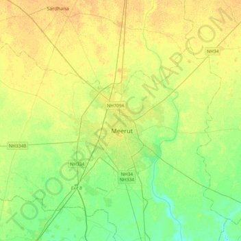
Name: Meerut topographic map, elevation, terrain.

Location: Meerut, Uttar Pradesh, 250001, India (28.83633 77.54619 29.15633 77.86619)

Average elevation: 226 m

Minimum elevation: 214 m

Maximum elevation: 236 m

Gear up for your next adventure:

🛶Kayak Accessories - Essential gear for safe and fun kayaking adventures
💡LED Camping Lantern - Illuminate your campsite with long-lasting lanterns
🥾Mountain Hiking Shoes - Shoes with superior grip for mountainous terrain
🧤Insulated Winter Gloves - Heavy-duty protection for sub-zero Canadian adventures
🛶Canoe Life Vest - Safety vest for water sports

As an Amazon Associate, this site earns from qualifying purchases at no extra cost to you.