Geolocate

Orai topographic map

Click on the map to display elevation.

About this map

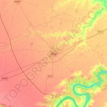
Name: Orai topographic map, elevation, terrain.

Location: Orai, Jalaun District, Uttar Pradesh, India (25.82639 79.29345 26.14639 79.61345)

Average elevation: 140 m

Minimum elevation: 100 m

Maximum elevation: 158 m

Gear up for your next adventure:

🔭Compact Binoculars - Lightweight optics for scouting trails and wildlife
🧴Insect Repellent - Protect yourself from bugs during outdoor adventures
🧭Orienteering Kit - Tools for map reading and navigation in the wild
🧥Ultralight Puffy Jacket - Maximum warmth that packs down to the size of an orange
👟Sport Hiking Sandals - Breathable footwear for water crossings and camp rest

As an Amazon Associate, this site earns from qualifying purchases at no extra cost to you.