Geolocate

Baghpat topographic map

Click on the map to display elevation.

About this map

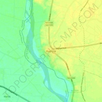
Name: Baghpat topographic map, elevation, terrain.

Location: Baghpat, Uttar Pradesh, 250609, India (28.90340 77.17934 28.98340 77.25934)

Average elevation: 219 m

Minimum elevation: 208 m

Maximum elevation: 227 m

Gear up for your next adventure:

🧢Outdoor Cap - Protective cap for sun and rain during hikes
🧴Outdoor Sunscreen - High SPF protection for high-altitude UV exposure
💡Solar Camping Lamp - Eco-friendly lighting for campsites
🧢Sun Protection Cap - Breathable cap to protect from sun exposure
🧤Thermal Hiking Gloves - Grip-enhanced gloves for cold-weather altitude trekking

As an Amazon Associate, this site earns from qualifying purchases at no extra cost to you.