Geolocate

Sravasti topographic map

Click on the map to display elevation.

About this map

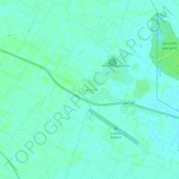
Name: Sravasti topographic map, elevation, terrain.

Location: Sravasti, Ikauna, Sharavasti District, Uttar Pradesh, India (27.48834 82.00636 27.52834 82.04636)

Average elevation: 113 m

Minimum elevation: 109 m

Maximum elevation: 117 m

Gear up for your next adventure:

🥾Mountain Trail Shoes - High-traction shoes for mountain trails
Lightweight Backpacking Tent - Compact tent for efficient hiking trips
🔭Compact Monocular - One-handed bird watching and trail spotting
🪑Ultralight Camping Stool - Compact seating for rest stops during long hikes
🛏️Sleeping Bag - Warm and compact sleeping bags for outdoor camping

As an Amazon Associate, this site earns from qualifying purchases at no extra cost to you.