
Mumbai topographic map
Click on the map to display elevation.
Mumbai
Mumbai is on a narrow peninsula on the southwest of Salsette Island, which lies between the Arabian Sea to the west, Thane Creek to the east and Vasai Creek to the north. Mumbai's suburban district occupies most of the island. Navi Mumbai is east of Thane Creek and Thane is north of Vasai Creek. Mumbai consists of two distinct regions: Mumbai City district and Mumbai Suburban district, which form two separate revenue districts of Maharashtra. The city district region is also commonly referred to as the Island City or South Mumbai. The total area of Mumbai is 603.4 km2 (233 sq mi). Of this, the island city spans 67.79 km2 (26 sq mi), while the suburban district spans 370 km2 (143 sq mi), together accounting for 437.71 km2 (169 sq mi) under the administration of Municipal Corporation of Greater Mumbai (MCGM). The remaining areas belong to various Defence establishments, the Mumbai Port Trust, the Atomic Energy Commission and the Borivali National Park, which are out of the jurisdiction of the MCGM. The Mumbai Metropolitan Region which includes portions of Thane, Palghar and Raigad districts in addition to Greater Mumbai, covers an area of 4,355 km2 (1681.5 sq mi). Mumbai lies at the mouth of the Ulhas River on the western coast of India, in the coastal region known as the Konkan. It sits on Salsette Island (Sashti Island), which it partially shares with the Thane district. Mumbai is bounded by the Arabian Sea to the west. Many parts of the city lie just above sea level, with elevations ranging from 10 m (33 ft) to 15 m (49 ft); the city has an average elevation of 14 m (46 ft). Northern Mumbai (Salsette) is hilly, and the highest point in the city is 450 m (1,476 ft) at Salsette in the Powai–Kanheri ranges. The Sanjay Gandhi National Park (Borivali National Park) is located partly in the Mumbai suburban district, and partly in the Thane district, and it extends over an area of 103.09 km2 (39.80 sq mi).
About this map
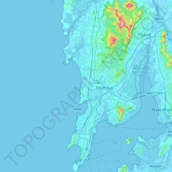
Name: Mumbai topographic map, elevation, terrain.
Location: Mumbai, Mumbai Suburban, Maharashtra, India (18.89396 72.77633 19.26948 72.98175)
Average elevation: 18 m
Minimum elevation: -3 m
Maximum elevation: 483 m
Other topographic maps
Click on a map to view its topography, its elevation and its terrain.
Navi Mumbai
India > Maharashtra > Navi Mumbai
Navi Mumbai (Marathi pronunciation: , also known by its former name New Bombay), is a planned city off the west coast of the Indian state of Maharashtra in Konkan division. The city is divided into two parts, North Navi Mumbai and South Navi Mumbai, for the individual development of Panvel Mega City, which…
Average elevation: 30 m
Alibag
India > Maharashtra > Alibag Taluka
Alibag is located about 120 km south of Mumbai, at 18°38′29″N 72°52′20″E / 18.64139°N 72.87222°E / 18.64139; 72.87222. The average elevation is 0 metres (0 feet).The District Government offices are located along the sea coast road. Alibag is the center place of Raigad District.
Average elevation: 12 m
Ichalkaranji
India > Maharashtra > Hatkanangle > Ichalkaranji
Ichalkaranji is located at 16°42′N 74°28′E / 16.7°N 74.47°E / 16.7; 74.47. It has an average elevation of 538 metres (1768 ft).
Average elevation: 562 m
Shrigonda
India > Maharashtra > Shrigonda
Shrigonda is a municipal council in Ahilyanagar - Ahmednagar district in the Indian state of Maharashtra. Shrigonda is located at 18°36′58″N 74°41′53″E / 18.616°N 74.698°E / 18.616; 74.698. It has an average elevation of 561 metres (1840 feet). As of the 2001 Indian census, Shrigonda had a…
Average elevation: 560 m
Sinnar
India > Maharashtra > Sinnar Taluka
Sinnar is located at 19°51′N 74°00′E / 19.85°N 74.0°E / 19.85; 74.0. It has an average elevation of 651.4 metres (2135 feet). Sinnar is one of the major industrial zones of Malegaon (MIDC) built around the city of Nashik which have multiple international production companies. It lies 30 km…
Average elevation: 684 m
Phaltan
India > Maharashtra > Phaltan
Phaltan has an average elevation of 568 meters (1,863 feet).
Average elevation: 561 m
Parbhani
India > Maharashtra > Parbhani
Parbhani is located at 19°16′N 76°47′E / 19.27°N 76.78°E / 19.27; 76.78. It has an average elevation of 347 metres.
Average elevation: 411 m
Kolhapur
India > Maharashtra > Karvir
Kolhapur is an inland city located in south-west Maharashtra state, 373 km (232 mi) south of Mumbai and 228 km (142 mi) south of Pune, 615 km (382 mi) north-west of Bengaluru, 530 km (330 mi) west of Hyderabad and 55 km (34 mi) west of Sangli. Within Maharashtra, Kolhapur's nearest cities and towns are…
Average elevation: 592 m
Satara
India > Maharashtra > Satara
Satara city has a tropical wet and dry climate (Köppen climate classification: Aw) that is influenced by the relatively high altitude and mountains surrounding the city. Summers are more hot than the winters. Satara city receives rainfall from 900 mm to 1,500 mm depending on the strength of the monsoon.
Average elevation: 748 m
Jejuri
India > Maharashtra > Purandhar
Jejuri is located at 18°17′N 74°10′E / 18.28°N 74.17°E / 18.28; 74.17. It has an average elevation of 718 metres (2355 feet) mean sea level.
Average elevation: 728 m
Ashta
India > Maharashtra > Walwa > Ashta
Ashta is a town and a municipal council in Sangli district in the state of Maharashtra, India. It is located at 16°57′N 74°24′E / 16.95°N 74.4°E / 16.95; 74.4. It has an average elevation of 567 metres (1860 ft). The name "Ashta" comes from the legend that Lord Shri Ram established eight…
Average elevation: 568 m
Lonavala
India > Maharashtra > Mawal
Adjacent to the Lohagad fort lies the visapur fort which is part of the Lohagad-Visapur fortification. Visapur Fort is larger and at a higher elevation than its twin- Lohagad. It was built during 1713-1720 CE by Balaji Vishwanath.
Average elevation: 613 m