Geolocate

Mangalwedha topographic map

Click on the map to display elevation.

About this map

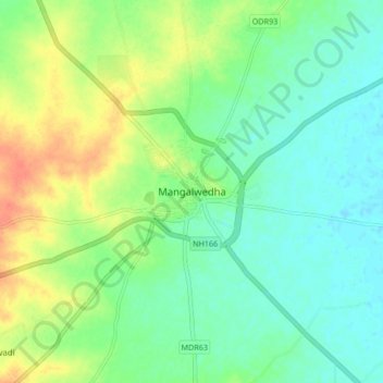
Name: Mangalwedha topographic map, elevation, terrain.

Location: Mangalwedha, Mangalvedhe, Solapur, Maharashtra, India (17.47288 75.40862 17.55288 75.48862)

Average elevation: 459 m

Minimum elevation: 444 m

Maximum elevation: 485 m

Gear up for your next adventure:

🚲Bike Repair Kit - Essential tools for on-trail mechanical issues
🥾Trekking Boots - Durable boots for long-distance trekking
🥾Trail Hiking Boots - Supportive boots for rough trails
Tent Footprint - Protect tent floor and increase durability
🧰Emergency Multi-Tool - Compact multi-tool for outdoor survival

As an Amazon Associate, this site earns from qualifying purchases at no extra cost to you.