Geolocate

Waksai topographic map

Click on the map to display elevation.

About this map

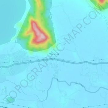
Name: Waksai topographic map, elevation, terrain.

Location: Waksai, Mawal, Pune District, Maharashtra, 410401, India (18.74363 73.43275 18.78363 73.47275)

Average elevation: 635 m

Minimum elevation: 613 m

Maximum elevation: 866 m

Gear up for your next adventure:

🌬️Windproof Camp Stove - Efficient cooking even on exposed mountain peaks
🔦LED Flashlight - Powerful and long-lasting flashlight for camping and emergencies
🧭GPS Tracker - Track your location in remote areas safely
🚑Survival Whistle - Signal for help across long distances in mountains
Lightweight Backpacking Tent - Compact tent for efficient hiking trips

As an Amazon Associate, this site earns from qualifying purchases at no extra cost to you.