Geolocate

Hingna topographic map

Click on the map to display elevation.

About this map

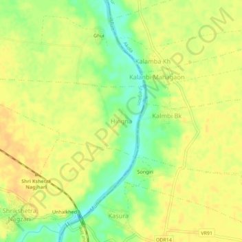
Name: Hingna topographic map, elevation, terrain.

Location: Hingna, Shegaon, Maharashtra, India (20.75092 76.74895 20.79092 76.78895)

Average elevation: 267 m

Minimum elevation: 247 m

Maximum elevation: 277 m

Gear up for your next adventure:

🔋Lithium AA Batteries - Long-lasting power that performs in extreme cold
🧤Thermal Hiking Gloves - Grip-enhanced gloves for cold-weather altitude trekking
🥾Hiking Shorts - Breathable shorts suitable for summer hikes
💡Portable Camping Lamp - Rechargeable lamp for campsite lighting
🧳Compression Sacks - Maximize space in your backpack by shrinking gear

As an Amazon Associate, this site earns from qualifying purchases at no extra cost to you.