Geolocate

Kegaon topographic map

Click on the map to display elevation.

About this map

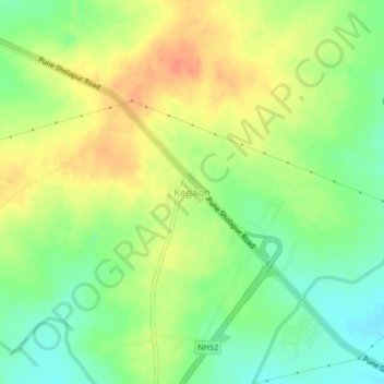
Name: Kegaon topographic map, elevation, terrain.

Location: Kegaon, Solapur North, Solapur, Maharashtra, 413255, India (17.69655 75.82926 17.73655 75.86926)

Average elevation: 475 m

Minimum elevation: 452 m

Maximum elevation: 498 m

Gear up for your next adventure:

🧥Waterproof Hiking Jacket - Protect yourself from rain and wind while hiking
🧤Insulated Winter Gloves - Heavy-duty protection for sub-zero Canadian adventures
🧊Insulated Water Bottle - Keeps drinks cold in summer and prevents freezing in winter
🍽️Titanium Camping Spork - Ultralight and indestructible eating utensil
🩹Moleskin Blister Pads - Direct protection for painful foot pressure points

As an Amazon Associate, this site earns from qualifying purchases at no extra cost to you.