Geolocate

Kalamba Lake topographic map

Click on the map to display elevation.

About this map

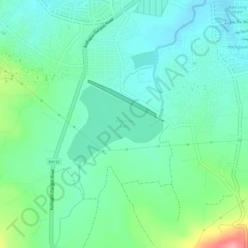
Name: Kalamba Lake topographic map, elevation, terrain.

Location: Kalamba Lake, Kolhapur, Maharashtra, India (16.65038 74.20698 16.65885 74.21795)

Average elevation: 606 m

Minimum elevation: 571 m

Maximum elevation: 693 m

Gear up for your next adventure:

Bushcraft Tarp - Versatile emergency shelter or gear protection
🦯Trekking Poles - Reduced impact on joints for steep topographic climbs
🥽Outdoor Goggles - Protective eyewear for outdoor activities
🦟Insect Repellent - Keep mosquitoes and black flies away in wooded areas
🥾Durable Hiking Shoes - Long-lasting shoes for frequent hiking

As an Amazon Associate, this site earns from qualifying purchases at no extra cost to you.