
Satara topographic map
Interactive map
Click on the map to display elevation.
About this map
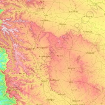
Name: Satara topographic map, elevation, terrain.
Location: Satara, Maharashtra, India (17.09116 73.53447 18.18243 74.90578)
Average elevation: 677 m
Minimum elevation: 46 m
Maximum elevation: 1,433 m
Other topographic maps
Click on a map to view its topography, its elevation and its terrain.
Navi Mumbai
India > Maharashtra > Navi Mumbai
Navi Mumbai (Marathi pronunciation: , also known by its former name New Bombay), is a planned city off the west coast of the Indian state of Maharashtra in Konkan division. The city is divided into two parts, North Navi Mumbai and South Navi Mumbai, for the individual development of Panvel Mega City, which…
Average elevation: 30 m
Shrigonda
India > Maharashtra > Shrigonda
Shrigonda is a municipal council in Ahilyanagar - Ahmednagar district in the Indian state of Maharashtra. Shrigonda is located at 18°36′58″N 74°41′53″E / 18.616°N 74.698°E / 18.616; 74.698. It has an average elevation of 561 metres (1840 feet). As of the 2001 Indian census, Shrigonda had a…
Average elevation: 560 m
Parbhani
India > Maharashtra > Parbhani
Parbhani is located at 19°16′N 76°47′E / 19.27°N 76.78°E / 19.27; 76.78. It has an average elevation of 347 metres.
Average elevation: 411 m
Satara
India > Maharashtra > Satara
Satara city has a tropical wet and dry climate (Köppen climate classification: Aw) that is influenced by the relatively high altitude and mountains surrounding the city. Summers are more hot than the winters. Satara city receives rainfall from 900 mm to 1,500 mm depending on the strength of the monsoon.
Average elevation: 748 m
Phaltan
India > Maharashtra > Phaltan
Phaltan has an average elevation of 568 meters (1,863 feet).
Average elevation: 561 m
Sinnar
India > Maharashtra > Sinnar Taluka
Sinnar is located at 19°51′N 74°00′E / 19.85°N 74.0°E / 19.85; 74.0. It has an average elevation of 651.4 metres (2135 feet). Sinnar is one of the major industrial zones of Malegaon (MIDC) built around the city of Nashik which have multiple international production companies. It lies 30 km…
Average elevation: 684 m
Alibag
India > Maharashtra > Alibag Taluka
Alibag is located about 120 km south of Mumbai, at 18°38′29″N 72°52′20″E / 18.64139°N 72.87222°E / 18.64139; 72.87222. The average elevation is 0 metres (0 feet).The District Government offices are located along the sea coast road. Alibag is the center place of Raigad District.
Average elevation: 12 m
Chakan
India > Maharashtra > Khed
Shiroli Chandus village, located 6 km north of Chakan, had been identified as the probable site for the proposed Pune International Airport, but due to the protests by the villagers & uneven topography, the site has been shifted to Purandar.
Average elevation: 624 m
Jejuri
India > Maharashtra > Purandhar
Jejuri is located at 18°17′N 74°10′E / 18.28°N 74.17°E / 18.28; 74.17. It has an average elevation of 718 metres (2355 feet) mean sea level.
Average elevation: 728 m
Dombivli
India > Maharashtra > Kalyan Taluka > Kalyan-Dombivli
Dombivli is located at 19°13′06″N 73°05′12″E / 19.218433°N 73.086718°E / 19.218433; 73.086718. It has an average elevation of 13.534 meters (44.403 feet). The land here is rough and rocky by nature. The Ulhas river flows from its north. The Arabian sea is about 50 km west from Dombivli.
Average elevation: 11 m
Ashta
India > Maharashtra > Walwa > Ashta
Ashta is a town and a municipal council in Sangli district in the state of Maharashtra, India. It is located at 16°57′N 74°24′E / 16.95°N 74.4°E / 16.95; 74.4. It has an average elevation of 567 metres (1860 ft). The name "Ashta" comes from the legend that Lord Shri Ram established eight…
Average elevation: 568 m
Ichalkaranji
India > Maharashtra > Hatkanangle > Ichalkaranji
Ichalkaranji is located at 16°42′N 74°28′E / 16.7°N 74.47°E / 16.7; 74.47. It has an average elevation of 538 metres (1768 ft).
Average elevation: 562 m
Lonavala
India > Maharashtra > Mawal
Adjacent to the Lohagad fort lies the visapur fort which is part of the Lohagad-Visapur fortification. Visapur Fort is larger and at a higher elevation than its twin- Lohagad. It was built during 1713-1720 CE by Balaji Vishwanath.
Average elevation: 613 m
Matheran
India > Maharashtra > Karjat Taluka
Matheran is an automobile-free hill station and a municipal council in the Karjat taluka of the Raigad district located in the Indian state of Maharashtra. Matheran is part of the Mumbai Metropolitan Region, and one of the smallest hill stations in India. It is located in the Western Ghats, at an elevation of…
Average elevation: 325 m