
Madhya Pradesh topographic map
Click on the map to display elevation.
Madhya Pradesh
Madhya Pradesh literally means "Central Province", and is located in the geographic heart of India in between the latitude of 21.6°N–26.30°N and longitude of 74°9'E–82°48'E. The state straddles the Narmada River, which runs east and west between the Vindhya and Satpura ranges; these ranges and the Narmada are the traditional boundaries between the north and south of India. The highest point in Madhya Pradesh is Dhupgarh, with an elevation of 1,350 m (4,429 ft).
About this map
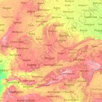
Name: Madhya Pradesh topographic map, elevation, terrain.
Location: Madhya Pradesh, India (21.07081 74.03030 26.86914 82.80942)
Average elevation: 347 m
Minimum elevation: 15 m
Maximum elevation: 1,313 m
Other topographic maps
Click on a map to view its topography, its elevation and its terrain.
Puducherry
India > Puducherry > Puducherry Taluk
The topography of Pondicherry is the same as that of coastal Tamil Nadu. Pondicherry's average elevation is at sea level and includes a number of sea inlets, referred to locally as "backwaters". Pondicherry experiences extreme coastal erosion as a result of a breakwater constructed in 1989, just to the south…
Average elevation: 10 m
Tiruchirappalli
India > Tamil Nadu > Tiruchirappalli
Tiruchirappalli is situated in central south-eastern India, almost at the geographic centre of the state of Tamil Nadu. The Cauvery Delta begins to form 16 kilometres (9.9 mi) west of the city where the river divides into two streams—the Kaveri and the Kollidam—to form the island of Srirangam. By road it…
Average elevation: 83 m
Bundi
India > Rajasthan > Bundi Tehsil
The town of Bundi is situated 35 km from Kota and 210 km from Jaipur. It is located at 25°26′N 75°38′E / 25.44°N 75.64°E / 25.44; 75.64 and an average elevation of 268 metres (879 feet). The city lies near a narrow gorge, and is surrounded on three sides by hills of the Aravalli Range. A…
Average elevation: 284 m
Kanchipuram
Kanchipuram is located at 12°59′N 79°43′E / 12.98°N 79.71°E / 12.98; 79.71, 72 km (45 mi) south-west of Chennai on the banks of the Vegavathi River, a tributary of the Palar River. The city covers an area of 11.6 km2 (4.5 sq mi) and has an elevation of 83.2 m (273 ft) above sea level.The land…
Average elevation: 82 m
Navi Mumbai
India > Maharashtra > Navi Mumbai
Navi Mumbai (Marathi pronunciation: , also known by its former name New Bombay), is a planned city off the west coast of the Indian state of Maharashtra in Konkan division. The city is divided into two parts, North Navi Mumbai and South Navi Mumbai, for the individual development of Panvel Mega City, which…
Average elevation: 30 m
Paonta Sahib
India > Himachal Pradesh > Paonta Sahib
Paonta Sahib is located at 30°26′17″N 77°37′26″E / 30.438°N 77.624°E / 30.438; 77.624. It has an average elevation of 389 metres (1,276 feet). It is on the bank of the river Yamuna, the river being the boundary between the states of Himachal Pradesh and Uttarakhand. It is situated near the…
Average elevation: 443 m
Uttarkashi
India > Uttarakhand > Bhatwari
It is the district headquarters of Uttarkashi district. Uttarkashi is situated on the banks of river Bhagirathi at an altitude of 1158 m above sea level. Uttarkashi is generally known as a holy town close to Rishikesh. It is located in the state of Uttarakhand in India. Uttarkashi is home to a number of…
Average elevation: 1,619 m
Chikkaballapura
India > Karnataka > Chikkaballapura taluk
The town of Chikkaballapur is approximately 56 km north of Bengaluru (formerly Bangalore) & Kolar city. Chikkaballapur has a high elevation located in the center of the Nandi Hills region. "Panchagiri" is a common descriptor of Chikkaballapur as it is surrounded by 5 picturesque hills among which Nandi Hills…
Average elevation: 929 m
Pavagada
India > Karnataka > Pavagada taluk
Pavagada is located at 14°06′N 77°16′E / 14.1°N 77.27°E / 14.1; 77.27. It has an average elevation of 646 metres (2,119 feet).
Average elevation: 643 m
Ichalkaranji
India > Maharashtra > Hatkanangle > Ichalkaranji
Ichalkaranji is located at 16°42′N 74°28′E / 16.7°N 74.47°E / 16.7; 74.47. It has an average elevation of 538 metres (1768 ft).
Average elevation: 562 m
Anantapur
India > Andhra Pradesh > Anantapur
Anantapur is located at 14°41′N 77°36′E / 14.68°N 77.6°E / 14.68; 77.6. It has an average elevation of 335 m (1,099 ft). It is located at a distance of 484 km from Vijayawada, 148 km from Kurnool and 210 km from Bengaluru which is the closest international airport.
Average elevation: 367 m
Alibag
India > Maharashtra > Alibag Taluka
Alibag is located about 120 km south of Mumbai, at 18°38′29″N 72°52′20″E / 18.64139°N 72.87222°E / 18.64139; 72.87222. The average elevation is 0 metres (0 feet).The District Government offices are located along the sea coast road. Alibag is the center place of Raigad District.
Average elevation: 12 m
Chittorgarh
India > Rajasthan > Chittaurgarh Tehsil
Chittorgarh is located at 24°53′N 74°38′E / 24.88°N 74.63°E / 24.88; 74.63. It has an average elevation of 394 metres (1292 ft).Chittorgarh is located in the southern part of the state of Rajasthan, in the northwestern part of India. It is located beside a high hill near the Gambhiri River.…
Average elevation: 442 m
Dharapuram
India > Tamil Nadu > Dharapuram
Dharapuram is located at 10°44′N 77°31′E / 10.73°N 77.52°E / 10.73; 77.52. Dharapuram town is situated along of the bank of Amaravathi River which flows from the south to north. Uppar River and dam, Nallathankal River and dam, Palar join the river Amaravathi. It has an average elevation of 245…
Average elevation: 252 m
Chidambaram
India > Tamil Nadu > Chidambaram
Chidambaram is located at 11°23′N 79°41′E / 11.39°N 79.69°E / 11.39; 79.69. The town is located in Cuddalore district of the South Indian state, Tamil Nadu, 215 km (134 mi) from Chennai. Chidambaram is located close to the shores of Bay of Bengal. The topography is almost plain with forests…
Average elevation: 5 m
Fatehpur Shekhawati
India > Rajasthan > Fatehpur Tehsil
Fatehpur is located at 27°59′N 74°57′E / 27.98°N 74.95°E / 27.98; 74.95. It has an average elevation of 324 metres (1066 ft). It is home to very rare Jojoba farm.
Average elevation: 327 m
Mount Abu
India > Rajasthan > Abu Road Tehsil
Mount Abu town, the only hill station in Rajasthan, is at an elevation of 1,220 m (4,003 ft). It has been a popular retreat from the heat of Rajasthan and neighboring Gujarat for centuries.
Average elevation: 914 m
Nowshera
India > Jammu and Kashmir > Nowshehra Tehsil
Given its spatial and demographic extent, Nowshera has been given the status of a Sub-District. It is a beautiful place with a number of tourist attractions including the fort of Mangla Devi, holy cave temple of Mangla Mata, Central Gurudwara of Sikhs in Nonial, Qila Darhal and other Dargahs and temples. The…
Average elevation: 668 m
Junagadh
India > Gujarat > Junagadh City Taluka
Junagadh city is located at 21°31′N 70°28′E / 21.52°N 70.47°E / 21.52; 70.47 at the foot of Mount Girnar, with the Arabian sea to the southwest, Porbandar to the north, and Amreli to the east. It has an average elevation of 107 metres (351 ft).
Average elevation: 163 m
Phulera
India > Rajasthan > Phulera Tehsil
Phulera is located at 26°52′N 75°14′E / 26.87°N 75.23°E / 26.87; 75.23. It has an average elevation of 387 metres (1269 feet).
Average elevation: 391 m
Beawar
India > Rajasthan > Beawar Tehsil
Beawar is located at 26°06′N 74°19′E / 26.1°N 74.32°E / 26.1; 74.32. It has an average elevation of 439 metres (1,440 ft).
Average elevation: 455 m
Nalgonda
India > Telangana > Nalgonda mandal
Nalgonda is located at 17°03′00″N 79°16′00″E / 17.050°N 79.2667°E / 17.050; 79.2667. It has an average elevation of 420 metres (1,380 ft).
Average elevation: 219 m
Chanderi
India > Madhya Pradesh > Chanderi Tahsil
Chanderi is located at 24°43′N 78°08′E / 24.72°N 78.13°E / 24.72; 78.13. It has an average elevation of 456 metres (1496 feet).
Average elevation: 440 m
Navsari
India > Gujarat > Navsari Taluka
Navsari is located at 20°57′N 72°56′E / 20.95°N 72.93°E / 20.95; 72.93. It has an average elevation of 9 metres or 30 feet above sea level. The city is located in southern Gujarat and is situated near the Purna River, within a few kilometers of the river's delta, which is west of the city and…
Average elevation: 14 m
Rudraprayag
India > Uttarakhand > Rudraprayag
Rudraprayag district is located at 30°17′N 78°59′E / 30.28°N 78.98°E / 30.28; 78.98. It has an average elevation of 895 metres (2,936 feet).
Average elevation: 1,140 m
Rajpipla
India > Gujarat > Nandod Taluka
Rajpipla is located at 21°47′N 73°34′E / 21.78°N 73.57°E / 21.78; 73.57. It has an average elevation of 148 metres (485 feet).
Average elevation: 50 m
Tiruvannamalai
India > Tamil Nadu > Tiruvannamalai
Tiruvannamalai is situated 196 km (122 mi) from the state capital Chennai and 210 km (130 mi) from Bangalore. The height of the Annamalai hill is approximately 2,669 ft (814 m). Tiruvannamalai is located at 12°00′N 79°03′E / 12°N 79.05°E / 12; 79.05. It has an average elevation of 200 metres…
Average elevation: 202 m
Porbandar
India > Gujarat > Porbandar Taluka
Porbandar is located at 21°37′48″N 69°36′0″E / 21.63000°N 69.60000°E / 21.63000; 69.60000. It has an average elevation of 1 metre (3 ft).
Average elevation: 18 m
Itanagar
India > Arunachal Pradesh > Itanagar EAC
Itanagar is located at 27°06′N 93°37′E / 27.1°N 93.62°E / 27.1; 93.62. It has an average elevation of 320 metres.
Average elevation: 539 m
Hodal
Hodal is a town and a municipal council, located, on Palwal Road in Palwal district in the Haryana state of India.It is Part of Braj region. Its language is Braj bhasha & Haryanvi. It is located at 27°53′39″N 77°22′09″E / 27.89417°N 77.36917°E / 27.89417; 77.36917 and has an average…
Average elevation: 190 m
Patiala
India > Punjab > Patiala Tahsil
Patiala is located at 30°19′N 76°24′E / 30.32°N 76.40°E / 30.32; 76.40. It has an average elevation of 250 metres (820 feet). During the short existence of PEPSU, Patiala served as its capital city.
Average elevation: 255 m
Bharuch
India > Gujarat > Bharuch Taluka
Bharuch is located at 21°42′N 72°58′E / 21.7°N 72.97°E / 21.7; 72.97. It has an average elevation of 15 metres (49 feet). Bharuch is a port city situated on the banks of the Narmada river. The damming of the Narmada caused the original port facilities to close, the nearest port is now in…
Average elevation: 15 m
Balaghat
India > Madhya Pradesh > Balagat Tahsil
Balaghat is located at 21°48′N 80°11′E / 21.800°N 80.183°E / 21.800; 80.183. It has an average elevation of 288 metres (944 feet).
Average elevation: 304 m
Pratapgarh
India > Rajasthan > Pratapgarh Tehsil
Pratapgarh District is a newly constituted district in Rajasthan state. it came into existence on 26 January 2008, as the 33rd district of Rajasthan. Pratapgarh is located at 24.03° N 74.78° E. It has an average elevation of 491 metres (1610 feet). It is said to be the second highest place in Rajasthan after…
Average elevation: 503 m
Rewa
India > Madhya Pradesh > Huzur Tahsil
Rewa is located on 24°32′17″N 81°17′43″E / 24.53806°N 81.29528°E / 24.53806; 81.29528. It has an average elevation of 259 metres (853 feet). Rewa is situated on Bank of Bihad and Bichhiya river, it's on rewa pletaue sarounded with and vindhya and kaimur ranges .
Average elevation: 317 m
Nakodar
India > Punjab > Nakodar Tahsil
Nakodar is located at 31°08′N 75°28′E / 31.13°N 75.47°E / 31.13; 75.47. It has an average elevation of 223 metres (731 feet). Nakodar lies on Moga-Jalandhar section of National Highway 703 (NH 703).
Average elevation: 231 m
Vagamon
Vagamon, due to its elevation and climate, has a unique ecosystem, leading to the emergence of rich natural vegetation, plant species, shola forests etc. From the early 20th century plantation grew crops like tea and coffee. Vagamon hills are home to less explored flora and fauna. A diversity study conducted…
Average elevation: 866 m
Sehore
India > Madhya Pradesh > Sehore Nagar Tahsil
Sehore is 37 km from the state capital, Bhopal, towards the south-west and on the Bhopal - Indore highway. Its height from mean sea level is between 1500 ft. and 2000 ft. Sehore is situated on the Western Railway line from Bhopal to Ratlam. It is surrounded by 7 districts: Bhopal, Raisen, Harda, Hoshangabad,…
Average elevation: 501 m
Ranebennur
India > Karnataka > Ranebennuru taluk
Ranebennuru is at the geographical center of Karnataka. 14°37′N 75°37′E / 14.62°N 75.62°E / 14.62; 75.62. It has an average elevation of 605 metres (1,985 ft). One of Karnataka's most important rivers – the Tungabhadra – flows along the southern border of Ranebennur taluk. Another river,…
Average elevation: 574 m
Suratgarh
India > Rajasthan > Suratgarh Tehsil
Suratgarh is located at 29°19′04″N 73°53′56″E / 29.317701°N 73.898935°E / 29.317701; 73.898935. It has an average elevation of 168 metres (551) feet. It is a Northern Part of Thar desert. Seasonal Ghaghar river runs through Northern part of tehsil. Suratgarh has Greenary in Northern part…
Average elevation: 177 m
Kavali
India > Andhra Pradesh > Kavali
Kavali is located at 14°54′47″N 79°59′35″E / 14.913001°N 79.992921°E / 14.913001; 79.992921. It has an average elevation of 17 metres (56 ft). The town is at a distance of 8 km from the Bay of Bengal.
Average elevation: 15 m
Huzurabad
India > Telangana > Huzurabad mandal
Huzurabad is at 18°12′N 79°25′E / 18.20°N 79.42°E / 18.20; 79.42. It has an average elevation of 271 metres (889 ft).
Average elevation: 270 m
Khurja
India > Uttar Pradesh > Khurja
Khurja is located at 28°15′N 77°51′E / 28.25°N 77.85°E / 28.25; 77.85. It has an average elevation of 197 metres (646 foot).
Average elevation: 198 m
Shivpuri
India > Madhya Pradesh > Shivpuri NagarTahsil
Shivpuri is a city and a municipality in Shivpuri district located in the central Indian state of Madhya Pradesh. It is in the Gwalior Division of northwest Madhya Pradesh and is the administrative headquarters of Shivpuri District. It is situated at an altitude of 1,515 feet (462 m) above sea level.
Average elevation: 442 m