Geolocate

Rudraprayag topographic map

Click on the map to display elevation.

Rudraprayag

Rudraprayag district is located at 30°17′N 78°59′E / 30.28°N 78.98°E / 30.28; 78.98. It has an average elevation of 895 metres (2,936 feet).

Wikipedia (CC-BY-SA 3.0)

About this map

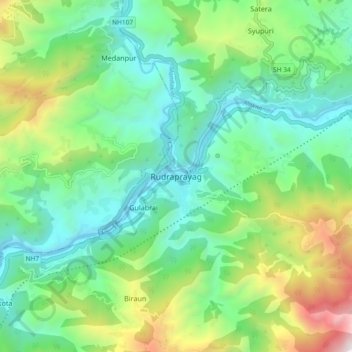
Name: Rudraprayag topographic map, elevation, terrain.

Location: Rudraprayag, Rudraprayag District, Uttarakhand, 246171, India (30.24656 78.94072 30.32656 79.02072)

Average elevation: 1,140 m

Minimum elevation: 594 m

Maximum elevation: 2,495 m

Gear up for your next adventure:

🔋Emergency Crank Radio - Weather alerts and power without needing batteries
🔋Solar Power Bank - Keep your GPS and devices charged during long outdoor trips
🛶Kayak Dry Bag - Waterproof storage for kayaking adventures
🥾Waterproof Trail Shoes - Shoes designed to handle wet terrain
🛁Quick-Dry Microfiber Towel - Space-saving towel that dries rapidly on the move

As an Amazon Associate, this site earns from qualifying purchases at no extra cost to you.