
Make a donation
Gear up for your next adventure:
As an Amazon Associate, this site earns from qualifying purchases at no extra cost to you.
Karaikudi topographic map
Click on the map to display elevation.
Make a donation
Gear up for your next adventure:
As an Amazon Associate, this site earns from qualifying purchases at no extra cost to you.
Karaikudi
Karaikudi is located in Sivagangai district of Tamil Nadu State. The Trichy–Rameswaram Highway passes through Karaikudi. The Thennar River flows through South Karaikudi. Karaikudi is located at 10°04′N 78°47′E / 10.07°N 78.78°E / 10.07; 78.78. It has an average elevation of 82 metres (269 ft). The terrain of Karaikudi is predominantly flat. Rocky areas are found in the surrounding areas of Karaikudi town with more rocks towards the western side of the town. The soil is of the hard red lateritic type and is not suitable for cultivation. The water table in the area is generally at depths of 3 to 6 ft (0.91 to 1.83 m) and rises to nearly 1 m (3 ft 3 in) below the ground level during rainy seasons. Since the 1970s, the water supply of the Karaikudi residents has depended on the deeper aquifers. The average maximum temperature is about 34 °C (93 °F), and average minimum temperature is about 24 °C (75 °F). The annual average rainfall in Karaikudi is about 920 millimetres (36 inches).
Make a donation
Gear up for your next adventure:
As an Amazon Associate, this site earns from qualifying purchases at no extra cost to you.
About this map
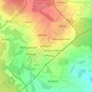
Name: Karaikudi topographic map, elevation, terrain.
Average elevation: 88 m
Minimum elevation: 62 m
Maximum elevation: 118 m
Make a donation
Gear up for your next adventure:
As an Amazon Associate, this site earns from qualifying purchases at no extra cost to you.