Geolocate

Dahod topographic map

Click on the map to display elevation.

About this map

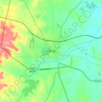
Name: Dahod topographic map, elevation, terrain.

Location: Dahod, Dahod Taluka, Dahod District, Gujarat, 389100, India (22.79588 74.21568 22.87588 74.29568)

Average elevation: 310 m

Minimum elevation: 276 m

Maximum elevation: 378 m

Gear up for your next adventure:

🧴Sunscreen SPF - Broad-spectrum sunscreen for outdoor activities
🧢Hiking Hat - Sun-protective and breathable hats for long treks
🧣Evaporative Cooling Towel - Beat the heat during intense summer climbs
Family Camping Tent - Spacious tent suitable for family camping trips
🥾Lightweight Hiking Shoes - Comfortable shoes for day hikes

As an Amazon Associate, this site earns from qualifying purchases at no extra cost to you.