Geolocate

Rewa topographic map

Click on the map to display elevation.

Rewa

Rewa is located on 24°32′17″N 81°17′43″E / 24.53806°N 81.29528°E / 24.53806; 81.29528. It has an average elevation of 259 metres (853 feet). Rewa is situated on Bank of Bihad and Bichhiya river, it's on rewa pletaue sarounded with and vindhya and kaimur ranges .

Wikipedia (CC-BY-SA 3.0)

About this map

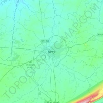
Name: Rewa topographic map, elevation, terrain.

Location: Rewa, Huzur Tahsil, Rewa, Madhya Pradesh, 486001, India (24.37590 81.13340 24.69590 81.45340)

Average elevation: 317 m

Minimum elevation: 271 m

Maximum elevation: 654 m

Other topographic maps

Click on a map to view its topography, its elevation and its terrain.

Dubi

India > Madhya Pradesh > Huzur Tahsil > Rewa

Average elevation: 312 m

Huzur Tahsil

India > Madhya Pradesh > Huzur Tahsil

Average elevation: 325 m

Gear up for your next adventure:

🧤Rechargeable Heated Gloves - Extreme warmth for Canadian winter expeditions
📷Outdoor Action Camera - Capture high-elevation views and rugged adventures
💡LED Headlamp - Hands-free illumination for night hiking and camping
🧶550 Survival Paracord - Versatile utility cord for emergency repairs and rigging
🕯️Camping Lantern - Illuminates your entire campsite with high-efficiency LEDs

As an Amazon Associate, this site earns from qualifying purchases at no extra cost to you.