Geolocate

Beawar topographic map

Click on the map to display elevation.

Beawar

Beawar is located at 26°06′N 74°19′E / 26.1°N 74.32°E / 26.1; 74.32. It has an average elevation of 439 metres (1,440 ft).

Wikipedia (CC-BY-SA 3.0)

About this map

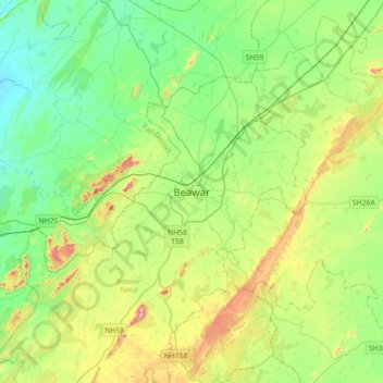
Name: Beawar topographic map, elevation, terrain.

Location: Beawar, Beawar Tehsil, Ajmer District, Rajasthan, 305900, India (25.93921 74.15270 26.25921 74.47270)

Average elevation: 455 m

Minimum elevation: 341 m

Maximum elevation: 731 m

Gear up for your next adventure:

🔋Lithium AA Batteries - Long-lasting power that performs in extreme cold
💧Filtered Water Bottle - Safe drinking water on the go
🏕️Camping Hammock - Integrated protection for sleeping between trees
🔪Outdoor Multitool - Versatile tool for repairs and food prep in the wild
🦯Trekking Poles - Reduced impact on joints for steep topographic climbs

As an Amazon Associate, this site earns from qualifying purchases at no extra cost to you.