Geolocate

Kala Amb topographic map

Click on the map to display elevation.

About this map

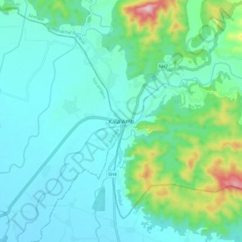
Name: Kala Amb topographic map, elevation, terrain.

Location: Kala Amb, Nahan, Sirmaur, Himachal Pradesh, 173030, India (30.45776 77.17091 30.53776 77.25091)

Average elevation: 387 m

Minimum elevation: 312 m

Maximum elevation: 715 m

Gear up for your next adventure:

🛶Waterproof Dry Bags - Keep electronics and clothes dry during river crossings
🎒Hiking Daypack - Lightweight and durable backpacks for day trips and excursions
🔋Lithium AA Batteries - Long-lasting power that performs in extreme cold
🥾Trekking Boots - Durable boots for long-distance trekking
🧣Merino Neck Gaiter - Protects against wind, sun, and cold at high altitudes

As an Amazon Associate, this site earns from qualifying purchases at no extra cost to you.