
Anantapur topographic map
Click on the map to display elevation.
Anantapur
Anantapur is located at 14°41′N 77°36′E / 14.68°N 77.6°E / 14.68; 77.6. It has an average elevation of 335 m (1,099 ft). It is located at a distance of 484 km from Vijayawada, 148 km from Kurnool and 210 km from Bengaluru which is the closest international airport.
About this map
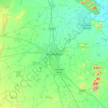
Name: Anantapur topographic map, elevation, terrain.
Location: Anantapur, Andhra Pradesh, 515001, India (14.51832 77.44650 14.83832 77.76650)
Average elevation: 367 m
Minimum elevation: 284 m
Maximum elevation: 694 m