
Make a donation
Gear up for your next adventure:
As an Amazon Associate, this site earns from qualifying purchases at no extra cost to you.
Bundi topographic map
Click on the map to display elevation.
Make a donation
Gear up for your next adventure:
As an Amazon Associate, this site earns from qualifying purchases at no extra cost to you.
Bundi
The town of Bundi is situated 35 km from Kota and 210 km from Jaipur. It is located at 25°26′N 75°38′E / 25.44°N 75.64°E / 25.44; 75.64 and an average elevation of 268 metres (879 feet). The city lies near a narrow gorge, and is surrounded on three sides by hills of the Aravalli Range. A substantial wall with four gateways encircles the city. It is served by Bundi railway station on Kota-Chittorgarh rail line. Bundi is also known as "Choti Kashi" as there are many old temples in the city, which has been built by kings at their reign.
Make a donation
Gear up for your next adventure:
As an Amazon Associate, this site earns from qualifying purchases at no extra cost to you.
About this map
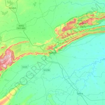
Name: Bundi topographic map, elevation, terrain.
Location: Bundi, Bundi Tehsil, Bundi District, Rajasthan, 323001, India (25.28161 75.47758 25.60161 75.79758)
Average elevation: 284 m
Minimum elevation: 224 m
Maximum elevation: 542 m
Make a donation
Gear up for your next adventure:
As an Amazon Associate, this site earns from qualifying purchases at no extra cost to you.