Geolocate

Bandikui topographic map

Click on the map to display elevation.

About this map

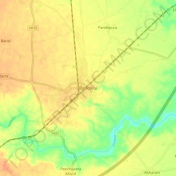
Name: Bandikui topographic map, elevation, terrain.

Location: Bandikui, Baswa Tehsil, Dausa, Rajasthan, 303313, India (27.00571 76.53527 27.08571 76.61527)

Average elevation: 278 m

Minimum elevation: 254 m

Maximum elevation: 293 m

Gear up for your next adventure:

🚲Handlebar Phone Mount - View topographic-map.com live while cycling
🥾Trekking Poles - Adjustable trekking poles to reduce knee stress and improve stability
🧭GPS Outdoor Watch - Smart watch for navigation and fitness tracking in nature
🧢Beanie Hat - Keep your head warm in cold weather
🧼Biodegradable Camp Soap - Environmentally friendly cleaning for gear and body

As an Amazon Associate, this site earns from qualifying purchases at no extra cost to you.