
Chittorgarh topographic map
Click on the map to display elevation.
Chittorgarh
Chittorgarh is located at 24°53′N 74°38′E / 24.88°N 74.63°E / 24.88; 74.63. It has an average elevation of 394 metres (1292 ft).Chittorgarh is located in the southern part of the state of Rajasthan, in the northwestern part of India. It is located beside a high hill near the Gambhiri River. Chittorgarh is located between 23° 32' and 25° 13' north latitudes and between 74° 12' and 75° 49' east longitudes in the southeastern part of Rajasthan state. The district encompasses 350.8 square km (3.17 per cent of the Rajasthan State) area of land.
About this map
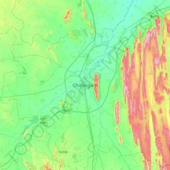
Name: Chittorgarh topographic map, elevation, terrain.
Average elevation: 442 m
Minimum elevation: 371 m
Maximum elevation: 617 m