East Nusa Tenggara topographic map
Interactive map
Click on the map to display elevation.
East Nusa Tenggara topographic map, elevation, terrain
About this map
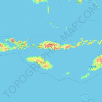
Name: East Nusa Tenggara topographic map, elevation, terrain.
Location: East Nusa Tenggara, Indonesia (-11.20857 118.37102 -6.75743 125.55008)
Average elevation: 31 m
Minimum elevation: 0 m
Maximum elevation: 2,411 m
Other topographic maps
Click on a map to view its topography, its elevation and its terrain.
Borneo
Before sea levels rose at the end of the last ice age, Borneo was part of the mainland of Asia, forming, with Java and Sumatra, the upland regions of a peninsula that extended east from present day Indochina. The South China Sea and Gulf of Thailand now submerge the former low-lying areas of the peninsula.…
Average elevation: 141 m
Kopeng
Indonesia > Special Region of Yogyakarta > Sleman Regency > Kepuhharjo
Average elevation: 755 m
Riau
In general, the geography of Riau consists of mountains, lowlands, and islands. The mountain area lies in the western part, namely the Bukit Barisan Mountains, near the border of West Sumatra. The elevation decreases towards the east, making most of the central and eastern part of the province covered with…
Average elevation: 115 m
Central Java
The Southern Serayu Mountains are part of the South Central Java Basin located in the southern part of the province. This mandala is a geoantiklin that extends from west to east along 100 kilometres and is divided into two parts separated by the Jatilawang valley, namely the western and eastern regions. The…
Average elevation: 83 m
South Sumatra
On the east coast the land consists of swamps and brackets which are affected by tides. Its vegetation is in the form of palmate plants and mangrove. A little more western is a vast lowland. Far to the west near the border of Bengkulu and Jambi lies the Bukit Barisan mountains, which divides South Sumatra and…
Average elevation: 123 m
West Papua
West Papua is located between 0–4 degrees South Latitude and 124–132 degrees East Longitude, just below the equator with an altitude of 0–100 m (0–328 ft) above sea level. The area of West Papua before the creation of Southwest Papua was 99,398.26 km2 (38,377.88 sq mi), and currently about 60,275.33…
Average elevation: 135 m
East Java
East Java has a tropical monsoon and savanna climate at lower elevation and subtropical at higher elevation. Compared with the western part of Java Island, East Java in general has less rainfall. Average rainfall is 1,900 mm per year, with a rainy season during the 100 days. The average temperature ranges…
Average elevation: 62 m
Bali
Bali's central mountains include several peaks over 2,000 metres (6,600 feet) in elevation and active volcanoes such as Mount Batur. The highest is Mount Agung (3,031 m; 9,944 ft), known as the "mother mountain", which is an active volcano rated as one of the world's most likely sites for a massive eruption…
Average elevation: 88 m