Geolocate

Songan A topographic map

Click on the map to display elevation.

👉 Easily get elevation data in JSON, GeoTIFF and KML formats using Elevation API
Thank you for supporting this site ❤️
Make a donation

About this map

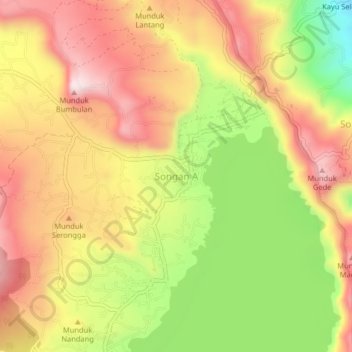
Name: Songan A topographic map, elevation, terrain.

Location: Songan A, Bangli, Bali, Indonesia (-8.24836 115.38786 -8.20836 115.42786)

Average elevation: 1,104 m

Minimum elevation: 840 m

Maximum elevation: 1,309 m

Gear up for your next adventure:

🧳Compression Sacks - Maximize space in your backpack by shrinking gear
🛏️Camping Sleeping Mat - Comfortable mats for sleeping outdoors
🧴Bear Spray Holster - Quick-access carry for essential Canadian wilderness safety
🚲Handlebar Phone Mount - View topographic-map.com live while cycling
💡Portable Camping Lamp - Rechargeable lamp for campsite lighting

As an Amazon Associate, this site earns from qualifying purchases at no extra cost to you.