Geolocate

Maracang topographic map

Click on the map to display elevation.

About this map

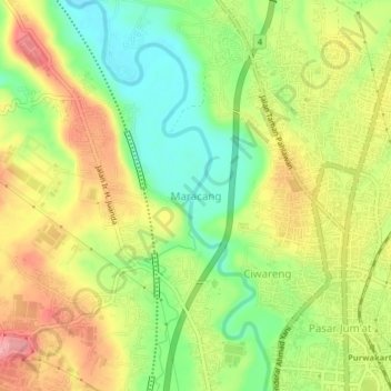
Name: Maracang topographic map, elevation, terrain.

Location: Maracang, West Java, 41113, Indonesia (-6.55726 107.40831 -6.51726 107.44831)

Average elevation: 81 m

Minimum elevation: 29 m

Maximum elevation: 136 m

Other topographic maps

Click on a map to view its topography, its elevation and its terrain.

Nagasari

Indonesia > West Java > Karawang

Average elevation: 12 m

Pasirkaliki

Indonesia > West Java > Bandung

Average elevation: 729 m

Cianjur

Indonesia > West Java

Average elevation: 604 m

Sukamaju

Indonesia > West Java > Bandung > Sukamaju

Average elevation: 702 m

Gear up for your next adventure:

Backpacking Tent - Lightweight tent for long-distance hiking trips
🧭Orienteering Kit - Tools for map reading and navigation in the wild
🥾Trekking Poles - Adjustable trekking poles to reduce knee stress and improve stability
🧶550 Survival Paracord - Versatile utility cord for emergency repairs and rigging
🧣Merino Neck Gaiter - Protects against wind, sun, and cold at high altitudes

As an Amazon Associate, this site earns from qualifying purchases at no extra cost to you.