Geolocate

Kaiya topographic map

Click on the map to display elevation.

About this map

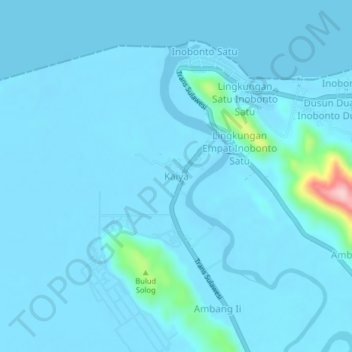
Name: Kaiya topographic map, elevation, terrain.

Location: Kaiya, Bolaang Mongondow, North Sulawesi, 95752, Indonesia (0.88870 124.06920 0.92870 124.10920)

Average elevation: 13 m

Minimum elevation: -3 m

Maximum elevation: 224 m

Gear up for your next adventure:

🧣Merino Neck Gaiter - Protects against wind, sun, and cold at high altitudes
🚲Bike Repair Kit - Essential tools for on-trail mechanical issues
🔨Vehicle Emergency Tool - Safety tool for remote road trips to trailheads
🧭GPS Handheld Device - Reliable GPS navigation for outdoor adventures
🧳Compression Sacks - Maximize space in your backpack by shrinking gear

As an Amazon Associate, this site earns from qualifying purchases at no extra cost to you.